- Product Description Description
- Table of Contents TOC
- List of Table & Figure LOT
- Get Free Sample PDF Sample PDF
Executive Summary: Europe Satellite Data Services Market
- Market Scope: Comprehensive regional satellite data services market analysis covering application segments, end-user categories, country-level leadership frameworks, and Earth observation technology trends.
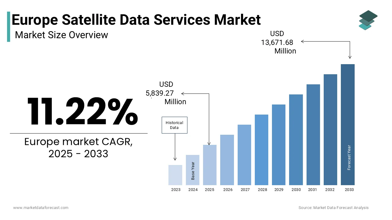
- Market Valuation: Valued at USD 5,839.27 million (2025), and projected to reach USD 13,671.68 million by 2033, registering a robust CAGR of 11.22% (2025–2033).
- Primary Growth Drivers: Mandated integration of Earth observation data in EU environmental policy, including the Copernicus Programme which generated over 22 petabytes of open data in 2023, and rapid adoption of precision agriculture across 180,000 German farms utilizing Sentinel-2 vegetation indices. Key industry trends include the proliferation of AI-powered analytics for carbon accounting and biodiversity monitoring, alongside increasing reliance on satellite feeds for critical infrastructure protection under the NIS2 Directive. Growth remains constrained by fragmented national data sovereignty requirements causing 3-to-6-month clearance delays, dependence on non-EU commercial constellations for sub-meter imagery, and latency gaps in real-time decision workflows.
Key Market Segment Metrics (2025–2033)
| Category | Leading Segment (2025 Position) | Fastest-Growing Segment |
|---|---|---|
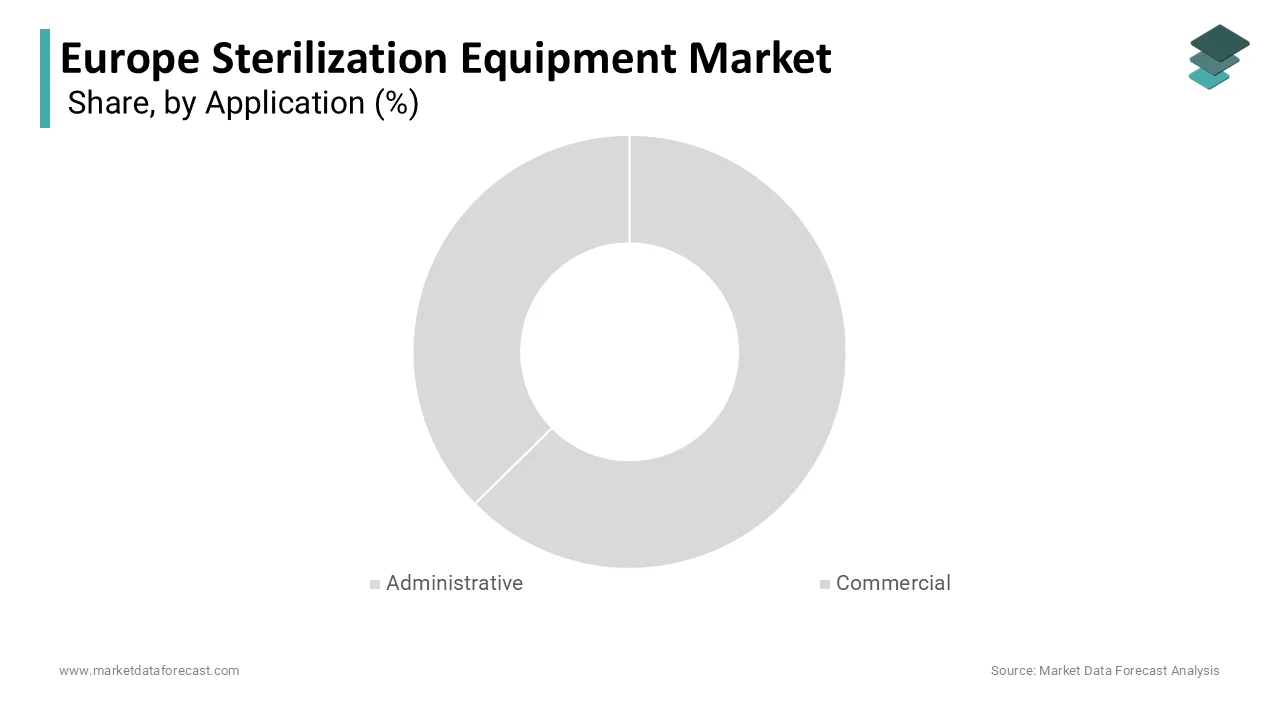
| By Application | Administrative application segment (held 45.8% of the market share in 2025) | Commercial segment (projected to expand at a CAGR of 12.3%) |
| By Sector / Vertical | Environmental applications (accounted for 28.2% of the market in 2025) | Defense & Security (expected to grow at a CAGR of 14.6%) |
| By End User | Government end-users (captured 38.3% of the market in 2025) | Data Analytics (likely to grow at the fastest CAGR of 13.1%) |
| By Region / Country | France (dominated regionally with 22.3% market share in 2025) | Italy and Germany (supported by COSMO-SkyMed SAR constellations and precision agriculture adoption) |
Major Market Players & Market Structure
Market Structure: Highly competitive European satellite data services landscape featuring leading aerospace, satellite communication, and Earth observation analytics providers competing on platform integration, secure processing infrastructure, and near-real-time radar intelligence.
Key Companies: Airbus Defence and Space, Eutelsat Communications S.A., SES S.A., Telespazio S.p.A., Inmarsat plc, Planet Labs PBC, Spire Global Inc., ICEYE Oy, BlackSky Technology, Inc., HawkEye 360, Inc., ExactEarth Ltd., Satellogic Inc., Deimos Imaging, Elecnor Deimos, GomSpace Group AB, OHB SE, Thales Alenia Space, SSC (Swedish Space Corporation), European Space Imaging GmbH, Orbits Edge, and Sky and Space Company Ltd.
Europe Satellite Data Services Market Size
The europe satellite data services market was valued at USD 5,250.20 million in 2024, is expected to reach USD 5,839.27 million in 2025, and is growing at a CAGR of 11.22% from 2025 to 2033 and reach USD 13,671.68 million by 2033.
Satellite data services are the acquisition, processing, and delivery of Earth observation information derived from optical, radar, and multispectral sensors aboard government and commercial spacecraft. These services support decision-making across agriculture, defense, urban planning, climate monitoring, and infrastructure management. The European countries operate within a unique dual framework combining public initiatives like the Copernicus Programme, where the world’s largest civilian Earth observation system, with a rapidly evolving commercial sector driven by high-resolutionimagery and analytics. According to the European Commission, the Copernicus Programme generated over 22 petabytes of free and open data in 2023 alone, serving more than 500 000 registered users across public and private institutions. As per the European Space Agency, Europe currently operates 32 active Earth observation satellites, including the Sentinel constellation and national missions from Germany, France, and Italy. The European Environment Agency utilizes this data stream to monitor land use changes with a spatial accuracy of 10 meters across all 27 member states. Furthermore, the EU’s Green Deal Digital Twin initiative relies on near-real-time satellite feeds to model climate impacts at regional scales.
MARKET DRIVERS
Mandated Integration of Earth Observation in EU Environmental and Climate Policy
European Union environmental legislation increasingly requires satellite-derived data as a compliance and monitoring tool, which is elevating the growth of Europe satellite data services market. According to the European Commission’s Implementing Regulation on the Monitoring Methodology for Land Use Change and Forestry, all member states must use Sentinel 2 optical imagery to verify carbon sequestration claims under the EU Climate Law. The regulation mandates annual land cover mapping at 20-meter resolution, a task impossible without systematic satellite data access. Similarly, the EU Biodiversity Strategy for 2030 requires member states to map and monitor 30% of terrestrial and marine areas using remote sensing, where the Joint Research Centre confirmed in 2023 that 100% of national reporting under this framework relied on Copernicus data. The Water Framework Directive also stipulates satellite-based monitoring of water body extent and algal blooms, with France and Spain using Sentinel 3 ocean color data to enforce compliance in over 12,000 water bodies. These legal obligations transform satellite data from an optional intelligence source into a regulatory necessity by ensuring sustained public sector procurement regardless of budget cycles.
Growth of Precision Agriculture and Digital Farming Platforms
The adoption of satellite data in agriculture due to policy incentives and farm-level economic pressures is additionally boosting the growth of Europe satellite data services market. In Germany alone, over 180,000 farms enrolled in digital farming programs in 2023, with 74% utilizing weekly Sentinel 2 vegetation indices for nitrogen management. The European Environment Agency estimates that precision agriculture using satellite data reduces nitrogen leaching by up to 22% and water consumption by 15% on average. Commercial platforms like eLEAF in the Netherlands and Satellogic partners in Spain now deliver sub-weekly field-level analytics on biomass moisture and stress, enabling real-time agronomic decisions. Additionally, the EU’s Farm Sustainability Tool for Nutrients mandates digital record keeping, further embedding satellite feeds into daily operations. This emergence of subsidy linkage, environmental compliance, and yield optimization ensures robust and scalable demand from Europe’s 9.1 million farms.
MARKET RESTRAINTS
Fragmented National Data Sovereignty and Security Clearance Requirements
The national security policies for the seamless use of high-resolution commercial satellite data are limiting the growth of Europe satellite data services market. According to the European Defence Agency, 14 EU member states maintain independent geospatial intelligence programs with restricted access protocols, requiring separate security clearances for data handling even within multinational projects. Similarly, Germany’s Federal Office for Information Security requires ISO 27001 certification plus additional Bundeswehr vetting for firms handling defense-related satellite analytics. A 2023 survey by the European Association of Remote Sensing Companies found that some of the commercial providers face delays of 3 to 6 months in delivering high-resolution data to cross-border clients due to divergent national classification regimes. This fragmentation increases operational costs, inhibits pan-European service scalability, and discourages startups from entering defense adjacent markets.
Dependence on Non-EU Commercial Constellations forSub-Meterr Imagery
Europe lacks sufficient domestic capacity in very high-resolution optical imaging, forcing reliance on US-based commercial providers like Maxar and Planet for sub-meter data to defense infrastructure and emergency response. The dependence on non-EU commercial constellations for sub-meter imagery is additionally restricting the growth of Europe satellite data services market. These export controls restrict real-time tasking and data sharing during crises. During the 2022 floods in Pakistan, European civil protection agencies were unable to task US satellites without US government approval, delaying damage assessment by 72 hours as per the European Civil Protection and Humanitarian Aid Operations report. Furthermore, licensing agreements often prohibit reprocessing or AI model training on raw pixels by limiting value-added analytics development within Europe. The European Commission’s 2023 Space Strategy acknowledges this strategic vulnerability and has allocated a few billionto develop the IRIS² secure connectivity constellation, but optical imaging gaps will persist until at least 2028.
MARKET OPPORTUNITIES
Expansion of AI-Powered Analytics for Carbon and Biodiversity Accounting
The emergence of machine learning and satellite data is unlocking new revenue streams in environmental compliance and voluntary carbon, which is one of the major opportunities for the growth of Europe satellite data services market. According to the European Commission’s Digital Twin Earth initiative, AI models trained on Sentinel 1 and 2 data can now estimate above-ground biomass with 89% accuracy across temperate forests by enabling automated carbon stock verification. Companies like Kayrros in France and Rezatec in the UK have developed proprietary algorithms that process free Copernicus feeds to deliver auditable carbon metrics to corporations complying with the EU Corporate Sustainability Reporting Directive. Similarly, the EU’s Nature Restoration Law requires member states to monitor habitat recovery using remote sensing. Startupsuch as Orbital Insight are deploying convolutional neural networks to detect species presence from spectral signatures in protected areas.
Integration into EU Critical Infrastructure Protection and Energy Security
Satellite data services are becoming essential for monitoring Europe’s energy and transportation networks amid growing physical and climate threats. The integration into EU infrastructure protection and energy security is expected to escalate the growth of Europe satellite data services market. According to the survey, all operators of essential services under the NIS2 Directive must implement geospatial monitoring for pipeline, power line, and rail corridor integrity by 2026. In response, companies like Airbus Defence and Space now offer persistent change detection services using synthetic aperture radar to identify ground subsidence or third-party intrusions along energy routes. The European Network of Transmission System Operators for Electricity documented that 100% of its members used satellite-based thermal anomaly detection in 2023 to prevent transformer failures during summer heatwaves. Following the Nord Stream pipeline incident, the EU Maritime Security Strategy mandated satellite surveillance of all subsea critical infrastructure in European waters, leading to contracts with ICEYE and Synspective for daily SAR monitoring. The Joint Research Centre has also developed a flood exposure model using Sentinel 1 data to assess risk to many energy substations. As climate volatility and geopolitical tensions escalate, satellite data shifts from supportive intelligence to a non-negotiable layer of operational resilience.
MARKET CHALLENGES
Latency and Interoperability Gaps in RReal-TimeDecision Workflows
The operational users in emergency response and defense face significant delays in transforming satellite feeds into actionable intelligence, which is attributed to posing a challenge to the growth of the European satellite data services market. According to the European Civil Protection Mechanism’s after-action review of the 2023 Greek wildfires, first responders waited an average of 11 hours to receive processed damage maps due to manual analysis bottlenecks and incompatible data formats across national agencies. The European Defence Agency reported that only 28% of EU military units have direct access to automated change detection tools, with most relying on static image downloads that lack integration with command-and-control systems. Furthermore, Copernicus data arrives in standard formats like NetCDF or GeoTIFF but rarely aligns with proprietary GIS platforms used by local governments, requiring costly reformatting. A 2023 study by the Technical University of Munich found that interoperability issues increase time to insight by 40 to 60% in time-sensitive scenarios.
Uncertainty in Long Term Public Procurement and Data Monetization Models
The commercial satellite data sector faces structural instability due to ambiguous pathways for monetizing public data and inconsistent public procurement cycles, which is further declining the growth of Europe satellite data services market. Public agencies often expect analytics to be delivered at marginal cost under open data principles, discouraging private investment in value-added development. Additionally, national space budgets fluctuate significantly, where the UK Space Agency’s Earth observation funding dropped in 2023, while France increased its by 18% by creating uneven market conditions. A 2024 survey by Eurospace revealed that 71% of small satellite analytics firms cite unpredictable public tenders as their top business risk. Without stable public-private partnership frameworks or clear rules on commercial reuse of Copernicus derivatives, innovation remains fragmented, and scale-up is hindered. This uncertainty stifles venture capital interest and limits Europe’s ability to compete with vertically integrated US data analytics firms.
REPORT COVERAGE
| REPORT METRIC | DETAILS |
| Market Size Available | 2025 to 2034 |
| Base Year | 2025 |
| Forecast Period | 2026 to 2034 |
| Segments Covered | By Application, Industry Vertical, End Use, and Region. |
| Various Analyses Covered | Global, Regional, and Country-Level Analysis, Segment-Level Analysis, Drivers, Restraints, Opportunities, Challenges; PESTLE Analysis; Porter’s Five Forces Analysis, Competitive Landscape, Analyst Overview of Investment Opportunities |
| Countries Covered | UK, France, Spain, Germany, Italy, Russia, Sweden, Denmark, Switzerland, Netherlands, Turkey, Czech Republic, Rest of Europe |
| Market Leaders Profiled | Airbus Defence and Space, Eutelsat Communications S.A., SES S.A., Telespazio S.p.A., Inmarsat plc, Planet Labs PBC, Spire Global Inc., ICEYE Oy, BlackSky Technology, Inc., HawkEye 360, Inc., ExactEarth Ltd., Satellogic Inc., Deimos Imaging (part of UrtheCast), Elecnor Deimos, GomSpace Group AB, OHB SE, Thales Alenia Space, SSC (Swedish Space Corporation), European Space Imaging GmbH, Orbits Edge, Sky and Space Company Ltd. |
SEGMENTAL ANALYSIS
By Application Insights
The Administrative segment held 45.8% of Euope satellite data services market in 2025. Administrative applications dominate due to binding EU legislation that requires public authorities to use satellite data for compliance monitoring and policy implementation. According to the European Commission, all 27 member states now use Copernicus Sentinel imagery as the primary source for reporting under the Land Use, Land Use Change and Forestry regulation, which mandates annual carbon stock verification across 180 million hectares of managed land. The European Environment Agency operates the High Resolution Layer program, which delivers standardized land cover maps at 10-meter resolution to national statistical offices used in 100% of Eurostat’s official rural development indicators as of 2023. These legal mandates transform satellite data from optional intelligence into an institutional utility by ensuring consistent public sector consumption regardless of technological cycles or budget fluctuations.
Satellite data is embedded in foundational public registries across Europe, including cadastral systems, disaster risk databases, and urban planning platforms. According to EuroGeographics, 24 EU countries have integrated Sentinel 2 imagery into their national land parcel identification systems to validate Common Agricultural Policy subsidy claims, covering over 150 million parcels annually. In Germany, the Federal Agency for Cartography and Geodesy updates its official topographic map series every 6 months using automated feature extraction from satellite feeds, reducing field survey costs by 38% as documented in its 2023 performance review. Similarly, Italy’s Civil Protection Department maintains a real-time flood exposure model using Sentinel 1 synthetic aperture radar, which triggers automatic alerts to 8,200 municipalities during extreme rainfall events. These institutionalized workflows ensure continuous demand from hundreds of public agencies by creating a stable administrative backbone that buffers the market against volatility in commercial or scientific funding streams.
The commercial segment is projected to expand at a CAGR of 12.3% from 2025 to 2033. Commercial growth is propelled by the insurance and financial sectors’ increasing reliance on satellite-derived risk analytics for underwriting and asset valuation. According to the European Insurance and Occupational Pensions Authority, 68% of European property insurers now use satellite data to assess flood, wildfire, and subsidence exposure at policy inception, up from 32% in 2020. Munich Re’s 2023 Natural Hazards Report documented that its European flood models incorporate daily Sentinel 1 radar data to update real-time risk scores for 25 million properties. Similarly, the European Central Bank’s climate stress tests in 2023 required banks to disclose physical risk exposure using geospatial analytics, prompting institutions like BNP Paribas and ING to contract satellite analytics firms for portfolio-wide asset screening. Startups such as ICEYE and Descartes Labs now offer subscription-based risk feeds that update building integrity scores within 24 hours of extreme weather events. As regulatory pressure for climate risk transparency intensifies under the EU Taxonomy and CSRD, demand for commercial satellite analytics in financial decision-making will continue to accelerate.
By Industry Vertical Insights
The environmental applications segment accounted in holding 28.2% of Europe's state data services market share in 2025. Environmental applications lead due to the EU’s institutionalized reliance on satellite data for climate policy implementation. The European Environment Agency uses Sentinel 5P data to monitor methane emissions from landfills and agriculture, with 2023 enforcement actions in Poland and Romania directly triggered by satellite-detected hotspots. Furthermore, the EU Forest Observatory, launched in 2023, processes 10 terabytes of daily satellite imagery to detect illegal logging in real time across 170 million hectares of EU forest, as confirmed by the Joint Research Centre. National agencies like France’s ONF and Sweden’s SFA integrate these feeds into operational workflows, creating sustained demand. Beyond climate, satellite data is now mandated for biodiversity and land degradation monitoring under new EU directives. According to the European Commission’s Nature Restoration Regulation, all member states must map and monitor 20% of their territory for habitat recovery by 2030 using remote sensing. Similarly, the upcoming Soil Health Law will require annual monitoring of organic carbon stocks using satellite-derived vegetation proxies by covering 110 million hectares of agricultural land.
The defense & Security segment is projected to grow at a CAGR of 14.6% from 2025 to 2033, with the European Union’s strategic shift toward autonomous intelligence capabilities following geopolitical disruptions. According to the European Defence Agency, the EU’s new IRIS² secure satellite communications program includes a dedicated Earth observation component with daily revisit capability over Eastern Europe and the Mediterranean, with initial services expected in 2026. In 2023, the EU Military Staff activated the Geospatial Intelligence Fusion Centre in Brussels, which integrates commercial SAR data from ICEYE and Capella Space with national optical feeds to support Common Security and Defence Policy missions. France’s Defence Ministry reported a 300% increase in satellite imagery tasking for border surveillance in 2023, along the Western Balkans migration routes. Similarly, Germany’s Bundeswehr now uses persistent change detection to monitor Russian military buildups within 100 kilometers of NATO borders, processing over 500 square kilometers of imagery daily. This institutionalization of satellite data inthe EU defense doctrine ensures robust and accelerating demand.
By End Use Insights
The government segment was the largest by capturing 38.3% of the European satellite data services market share in 2025. The growth of the segment is driven by the EU’s systematic use of processed analytics for regulatory enforcement and public service delivery. According to the European Commission, over 90% of Copernicus downstream services funded under the Horizon Europe program deliver ready-to-use analytics, such as deforestation alerts or crop yield forecasts, rather than unprocessed pixels. The European Environment Agency’s Flood Observatory provides automated damage assessment maps within 6 hours of extreme rainfall, used by 23 national civil protection agencies in 2023. Similarly, Eurostat’s Urban Audit program relies on machine learning models trained on Sentinel data to classify land use in 800 cities, feeding official statistics on urban sprawl. National agencies like Italy’s ISPRA and Spain’s AEMET maintain in-house analytics teams that convert satellite feeds into policy indicators, creating consistent demand for structured, validated outputs. According to the European Space Agency, the average European user now accesses 12 analytics layers per satellite image, including change detection, biomass estimation,n and infrastructure mapping. In agriculture, platforms like eLEAF deliver weekly nitrogen recommendation maps derived from Sentinel 2 by eliminating the need for farmer interpretation. This shift is enabled bcloud-baseded platforms like Google Earth Engine and ESA’s WEkEO, which provide scalable processing infrastructure.
The data analytics segment is likely to grow at the fastest CAGR of 13.1% from 2025 to 2033, with the emergence of large geospatial foundation models that automate complex interpretation tasks across sectors. According to the European Commission’s AI Office, the EU’s first open geospatial foundation model, released in partnership with CNES and DLR in early 2024, can detect 500 infrastructure types from satellite imagery with 92% accuracy, thereby reducing manual analysis time by 80%. Startups like Orbital Insight and Picterra now offerapplication-specificc models for carbon stock estimation or illegal fishing detection via API, with over 1 200 European clients as of Q1 2024. The European Environment Agency has integrated these models into its Nature Restoration monitoring system, enabling automated habitat classification across 1 million square kilometers. According to the European Financial Reporting Advisory Group, over 400 firms used satellite-derived carbon and water data in their 2023 disclosures, with analytics providers like Kayrros offering third-party verified reports compliant with ISSB standards. The upcoming Carbon Removal Certification Framework will require similar verification for all removal projects by covering an estimated 5 million hectares by 2027. Financial institutions are also driving demand; the European Central Bank’s climate stress tests now accept only analytics from providers registered in the EU’s GeoCert certification scheme, which validates methodology transparency. This regulatory push transforms satellite analytics from a discretionary tool into a compliance necessity by ensuring exponential growth as reporting obligations expand.
COUNTRY LEVEL ANALYSIS
France Satellite Data Services Market Analysis
France was the top performer of the European satellite data services market by holding 22.3% of the market share in 2025, as the EU’s primary hub for both governmental and commercial Earth observation. According to the French Ministry for Higher Education and Research, public investment in space applications exceeded EUR 2.4 billion in 2023, with 38% allocated to satellite data services. France’s Defence Ministry operates the CSO optical constellation and Pleiades Neo commercial fleet, ensuring sovereign access to sub-30-centimeter imagery. The country also leads EU climate monitoring initiatives; the Copernicus Climate Change Service is operated by Météo France under ECMWF coordination.
Germany Satellite Data Services Market Analysis
Germany's satellite data services market was positioned second by capturing 19.2% of the market share in 2024, with its advanced industrial integration of satellite analytics in energy, agriculture,e and automotive sectors. According to the German Aerospace Center, over 1,200 public and private entities used Copernicus data in 2023 through the national DLR Earth Observation Portal. Germany’s energy transition drives demand, where the Federal Network Agency mandates satellite-based monitoring of all new solar and wind installations for grid integration planning. Additionally, automotive firms like BMW use high-resolution imagery for factory site selection and supply chain resilience. The presence of research powerhouses like Fraunhofer and Max Planck ensures continuous innovation in analytics, while strict data sovereignty laws favor domestic providers.
United Kingdom Satellite Data Services Market Analysis
The United Kingdom satellite data services market growth is likely to grow with the world's leading commercial analytics firms and strong defense applications, despite post Brexit challenges. According to the UK Space Agency, the country hosts over 60 satellite data analytics companies, including Rezatec and Satellite Applications Catapult, which serve global clients from London and Harwell campuses. The Ministry of Defence’s Skynet 6 program includes integrated Earth observation tasking, with daily imagery used for global force protection. Civil applications are equally robust; the Environment Agency’s flood forecasting system processes Sentinel 1 data in real time to protect 5 million properties. Although excluded from Copernicus core funding, the UK secured associate membership in 2023, ensuring continued data access.
Italy Satellite Data Services Market Analysis
Italy's satellite data services market growth is likely to grow with its national COSMO SkyMed synthetic aperture radar constellation and strong environmental monitoring needs. According to the Italian Space Agency, the four-satellite COSMO SkyMed Second Generation system provides daily coverage of the Mediterranean with 1-meter resolution, used extensively by civil protection and defense agencies. In 2023, the Civil Protection Department activated over 200 satellite tasking requests for landslide and flood monitoring in the Apennines and Alps. Italy also leads in agricultural applications; the Ministry of Agriculture’s SIGIT platform uses Sentinel data to verify subsidy claims for 1.8 million farms.
Netherlands Satellite Data Services Market Analysis
The Netherlands satellite data services market growth is likely to be driven by the commercial satellite analytics and water management applications. According to the Netherlands Space Office, over 40 geospatial startups operate in the Dutch Water Campus and Space Delta clusters, including VanderSat and Sarmap, specializing in soil moisture and flood modeling. The country also hosts major cloud processing infrastructure, where ESA’s WEkEO platform is co-operated by EUMETSAT in Darmstadt and the Royal Netherlands Meteorological Institute.
COMPETITIVE LANDSCAPE
The European satellite data services market features a dual competitive structure comprising large integrated aerospace primes and agile specialized analytics startups. Incumbents like Airbus and e-GEOS dominate high-resolution optical and radar data provision through owned constellations and decades-long institutional relationships, while newer entrants compete on algorithmic innovation and vertical domain expertise in agriculture, finance, or carbon accounting. Competition is not primarily on price but on data freshness, latency,cy analytical accuracy, and compliance with EU data sovereignty and security regulations. Fragmentation persists due to national defense preferences and varying levels of digital maturity across member states, yet the trend toward AI-powered analytics and cloud delivery is consolidating value in platforms that offer automated, scalable,e and auditable insights rather than raw imagery alone.
KEY MARKET PLAYERS
Some of the companies that are playing a dominating role in the global europe satellite data services market include
- Airbus Defence and Space
- Eutelsat Communications S.A.
- SES S.A.
- Telespazio S.p.A.
- Inmarsat plc
- Planet Labs PBC
- Spire Global Inc.
- ICEYE Oy
- BlackSky Technology, Inc.
- HawkEye 360, Inc.
- ExactEarth Ltd.
- Satellogic Inc.
- Deimos Imaging (part of UrtheCast)
- Elecnor Deimos
- GomSpace Group AB
- OHB SE
- Thales Alenia Space
- SSC (Swedish Space Corporation)
- European Space Imaging GmbH
- Orbits Edge
- Sky and Space Company Ltd.
TOP LEADING PLAYERS IN THE MARKET
- Airbus Defence and Space is a leading European provider of satellite data services with integrated capabilities spanning satellite manufacturing, optics,l and radar data acquisition, and AI-powered analytics. The company operates the Pleiades Neo and TerraSAR X constellations, delivering sub-300 centimeter imagery to defense, environmental, and infrastructure clients across Europe and globally. Airbus has strengthened its position by launching the OneAtlas platform, which offers on-demand analytics foragricultural carbonn monitoring and critical infrastructure protection. In recent years,s the company secured multi-year contracts with the European Union Agency for the Space Programme to support Copernicus services and expanded its geospatial artificial intelligence team in Toulouse to accelerate automated feature extraction for public sector users in the European satellite data services market.
- Thales Alenia Space is a major European satellite manufacturer and data services enabler with a strong footprint in Earth observation mission design and ground segment development. While primarily a systems integrator, the company plays a critical role in the satellite data value chain by deliveringend-to-endd solutions for institutional clients, including the European Space Agency and national space agencies. Thales Alenia Space has reinforced its market presence by co-developing the next generation of Copernicus Sentinel satellites and building secure data processing infrastructure for the EU’s IRIS² secure connectivity program. The company also partners with analytics startups to embed edge processing capabilities directly into ground stations, reducing latency for defense and emergency response applications in theEuropeane satellite data services market.
- e-GEOS is a premier European satellite data services provider jointly owned by Leonardo and Airbus, operating Italy’s COSMO SkyMed synthetic aperture radar constellation. The company delivers high revisit radar imagery and value-added analytics for defense emergency response,se and maritime surveillance across Europe and international markets. e-GEOS has strengthened its position by launching the Geospatial Intelligence as a Service platform offering automated flood detection, illegal fishing alert,s and infrastructure deformation monitoring. In 20,23, the company signed framework agreements with the European Maritime Safety Agency and the Italian Civil Protection Department to provide near-real-time radar analytics. Its integration of COSMO SkyMed Second Generation data with optical feeds and artificial intelligence models ensures rapid actionable intelligence for both public and commercial users in tEuropeanope satellite data services market.
TOP STRATEGIES USED BY THE KEY MARKET PARTICIPANTS
Key players in the European satellite data services market invest heavily in artificial intelligence and cloud-based analytics platforms to transform raw imagery into decision-ready intelligence for regulated sectors. They secure long-term institutional contracts with EU agencies and national governments through participation in Copernicus IRIS² and national defense programs, ensuring stable revenue streams. Companies pursue vertical integration by combining satellite manufacturing groundg data acquisition, and analytics under one roof to control quality and reduce latency. Strategic partnerships with agri tech, climate tech, and insurance firms enable co-development of sector-specific solutions aligned with EU regulatory mandates. Additionally, they prioritize data sovereignty and secure processing infrastructure to meet stringent EU defense and critical infrastructure protection requirements, enhancing trust among public sector clients.
MARKET SEGMENTATION
This research report on the europe satellite data services market is segmented and sub-segmented into the following categories.
By Application
- Administrative
- Commercial
By Industry Vertical
- Environmental
- Defense & Security
By End Use
- Government
- Data Analytics
By Country
- France
- Germany
- United Kingdom
- Italy
- Netherlands
- Rest of Europe