- Product Description Description
- Table of Contents TOC
- List of Table & Figure LOT
- Get Free Sample PDF Sample PDF
Market Size, 2025
$30.66 BnMarket Estimate, 2026
$33.7 BnMarket Forecast, 2034
$71.71 BnCAGR, 2026–2034
9.9%Executive Summary: Europe Geospatial Analytics Market
- Market Scope: Comprehensive European geospatial analytics market analysis covering component types, solutions, deployment models, application verticals, country-level frameworks, and adoption metrics.
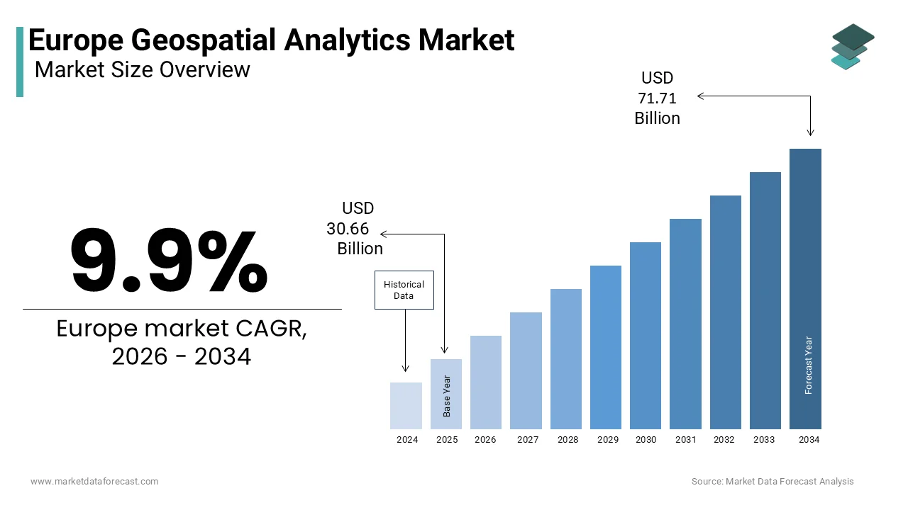
- Market Valuation: Valued at USD 30.66 billion (2025), reaching USD 33.70 billion (2026), and projected to grow to USD 71.71 billion by 2034, registering a robust CAGR of 9.9% (2026–2034).
- Primary Growth Drivers: Driven by the EU Green Deal, digital twin initiatives, smart city development, AI-powered spatial intelligence, and increasing climate monitoring requirements. Key opportunities include synthetic aperture radar (SAR)-based analytics, AI integration, and precision agriculture, balanced against challenges such as fragmented data governance, GDPR constraints, and cloud platform dependencies.
Key Market Segment Metrics (2026–2034)
| Category | Leading Segment (2025 Position) | Fastest-Growing Segment |
|---|---|---|
| By Component | Solutions (dominated the market in 2025 due to widespread GIS software and AI mapping adoption) | Services (expected to expand rapidly due to rising demand for consulting, integration, and managed services) |
| By Solution | Thematic Mapping & Spatial Analysis (led market due to use in urban planning and environmental monitoring) | Data Integration & ETL Solutions (projected to record highest growth driven by satellite, LiDAR, and IoT data volumes) |
| By Deployment | Cloud (accounted for 58.4% of the market in 2025, supported by scalability and cost-efficiency) | Cloud Deployment (expected to register highest CAGR of 22.7% via subscription-based SME adoption) |
| By Application | Climate Change (held 36.6% of the market in 2025, supported by EU climate policies and risk assessments) | Disaster Management & Risk Reduction (anticipated to witness fastest CAGR of 21.3% for emergency response) |
| By Country | Germany (leading contributor, followed by the United Kingdom and France) | Germany and United Kingdom (driven by heavy investments in digital twins and smart city infrastructure) |
Major Market Players & Market Structure
Market Structure: Highly competitive European market characterized by investments in AI-powered geospatial analytics, cloud-native GIS platforms, digital twin technologies, Earth observation capabilities, satellite imagery analytics, strategic partnerships, and interoperable spatial data ecosystems supporting smart cities, environmental monitoring, transportation, and defense applications.
Key Companies: Esri Inc., Hexagon AB, Trimble Inc., Maxar Technologies Inc., Airbus Defence and Space, Oracle Corporation, SAP SE, Google LLC, IBM Corporation, Precisely Inc., HERE Technologies, TOMTOM International BV, L3Harris Technologies, Inc., Fugro N.V., Bentley Systems Incorporated, Planet Labs PBC, Mapbox Inc., Geospin GmbH, Geocento Ltd., and Orbital Insight Inc.
Europe Geospatial Analytics Market Size
The europe geospatial analytics market was valued at USD 30.66 billion in 2025, is expected to reach USD 33.7 billion in 2026, and is growing at a 9.9% CAGR from 2026 to 2034, and is projected to reach USD 71.71 billion by 2034.
Geospatial analytics is the process of analyzing data with a spatial or location-based component to identify patterns, trends, and relationships, often using tools like Geographic Information Systems (GIS). Unlike traditional mapping, modern geospatial analytics enables predictive modeling, real-time monitoring, and pattern recognition across sectors, including urban planning, agriculture, defense, insurance, and environmental management. Geospatial industry estimates indicate that approximately 80% of data has a spatial component, particularly for local government policymaking, which emphasizes its foundational role in evidence-based governance across various sectors. The European Union's Copernicus Programme, the world’s largest Earth observation system, makes available over 65 petabytes of free and open geospatial data through the Copernicus Data Space Ecosystem, which produces up to 30 terabytes of new data daily. Simultaneously, the Digital Europe Programme is a key EU funding instrument, with an overall budget of over €7.5 billion, that directs significant investment toward fostering AI-driven geospatial innovation through initiatives like the European Data Spaces. Geospatial analytics has evolved from a niche technical tool into a strategic enabler of resilient, data-driven decision-making across public and private sectors, with climate adaptation, energy transition, and digital sovereignty now central to the EU agenda.
MARKET DRIVERS
EU Green Deal and Climate Adaptation Mandates Drive Demand for Environmental Monitoring
The European Green Deal’s binding climate targets have created a structural need for high-fidelity geospatial analytics to monitor emissions, land use change, and ecosystem health, which propels the growth of the European geospatial analytics market. The European Union has an official plan to stop adding to climate change by 2050, and has set a goal to cut emissions by more than half by 2030 compared to 1990 levels. This requires granular tracking of deforestation, soil carbon, urban heat island, and renewable energy site suitability, all dependent on geospatial intelligence. Authorities launched a new system in 2023 that employs technology to find illegal tree cutting almost as it happens. These regulatory and operational imperatives ensure sustained institutional demand for advanced geospatial analytics as a core instrument of climate governance.
Digital Twin Initiatives and Urban Planning Modernization Fuel Public Sector Adoption
Rapid deployment of geospatial analytics in European cities is creating the foundational layer for digital twin ecosystems that simulate urban dynamics and guide infrastructure investment, and thereby fuel the growth of the European geospatial analytics market. Many large European cities have started utilizing digital twin technology. These digital models integrate data from various urban elements like building information, traffic flow, utility networks, and environmental sensors. Furthermore, the revised INSPIRE Directive now mandates interoperable geospatial datasets across all public agencies, enabling cross-sectoral analysis for housing, transport, and emergency response. These policy drivers transform geospatial analytics from a planning support tool into an operational necessity for urban resilience, service efficiency, and participatory governance in an increasingly data-governed public sector.
MARKET RESTRAINTS
Fragmented Data Governance and National Sovereignty Concerns Limit Cross-Border Data Flows
Divergent national regulations on data privacy, security classification, and sovereignty impede seamless cross-border analysis and expansion of the European geospatial analytics market. Individual member states continue to maintain restrictive controls over high-resolution imagery and critical infrastructure mapping, even as the EU promotes open data through its Copernicus program and the European Data Strategy. This fragmentation prevents pan-European risk modeling for insurers or logistics firms needing continent-wide consistency. Besides, the General Data Protection Regulation complicates the integration of location data with personal identifiers, even for anonymized mobility studies. The lack of a unified European geospatial data trust framework means companies must navigate 27 distinct compliance regimes, increasing cost and complexity. The complete potential of continental-scale geospatial analytics will remain unrealized until harmonized rules emerge.
Shortage of Skilled Workforce and Interdisciplinary Expertise Constricts Implementation
The rapid advancement of geospatial technologies has outpaced the availability of professionals, which further hinders the expansion of the European geospatial analytics market. These professionals can effectively bridge geospatial science, data engineering, and domain-specific applications. This gap is most acute in sectors like agriculture and insurance, where domain knowledge must be combined with spatial modeling skills. Consequently, many organizations rely on external consultants or off-the-shelf platforms that lack customization, reducing analytical depth. The deployment of high-value geospatial analytics will remain limited to a few tech-advanced organizations unless scaled education initiatives and upskilling programs are implemented.
MARKET OPPORTUNITIES
Integration of Synthetic Aperture Radar and AI Enables All-Weather Monitoring Capabilities
The fusion of synthetic aperture radar satellite data with artificial intelligence is opening fresh opportunities for the growth of the European geospatial analytics market. This can help in all-weather geospatial analytics capabilities across Europe. Unlike optical imagery, radar penetrates clouds, smoke, fog, and darkness, enabling continuous monitoring of critical infrastructure, agricultural fields, and disaster zones. Companies offer commercial radar analytics that detect millimeter-scale ground deformation for dam safety or subsidence in urban areas. This technological convergence overcomes Europe’s frequent cloud cover limitations and establishes radar analytics as a resilient backbone for climate and security applications.
Expansion of Precision Agriculture and Farm Sustainability Compliance Drives Rural Adoption
Farms are adopting data-driven practices to meet sustainability mandates and optimize resource use, which in turn creates new prospects for the expansion of the European geospatial analytics market. There is a growing requirement for European Union farms that receive direct payments to maintain digital records of fertilizer, pesticide, and water usage, with location verification becoming a standard practice. The use of advanced technology is rapidly increasing, with a significant number of farms now employing satellite or drone-based data analysis for tasks such as optimizing input application rates and predicting future yields. Geospatial analytics serves as a key enabler of both productivity and environmental stewardship in the rural economy, given the significant share of EU land occupied by agriculture.
MARKET CHALLENGES
Ambiguity in Legal Frameworks for High-Resolution Imagery Raises Liability Risks
The increasing availability of sub-meter resolution satellite and drone imagery has created legal uncertainty around privacy, property rights, and data ownership in the region, which ultimately hampers the growth of the European geospatial analytics market. Commercial providers are raising concerns about surveillance and misuse by offering imagery at 30-centimeter resolution or better, in contrast to the Copernicus Programme's open data at 10 meters. In 2023, a German court ruled that repeated drone mapping of private agricultural fields without consent violated property rights even for public interest research. Similarly, insurers using geospatial analytics for risk scoring face challenges under the EU’s proposed Artificial Intelligence Act if models lack explainability. This regulatory gray zone discourages innovation in high-resolution applications such as urban change detection or infrastructure monitoring due to fear of litigation or non-compliance. The market risks underutilizing its most potent data sources in the absence of clear legal boundaries.
Overreliance on US-based Cloud and AI Platforms Affects European Technological Sovereignty
The region's dependence on non-EU technology providers for the AI frameworks and computational infrastructure that support advanced geospatial analytics remains a major obstacle for the European geospatial analytics market. This is the situation when Europe has strong Earth observation capabilities. According to sources, many European geospatial startups and public agencies use US-based cloud platforms like Amazon Web Services or Google Earth Engine for storage, processing, and machine learning due to their scalability and pre-trained models. This reliance creates vulnerabilities in data sovereignty, ty secur, and long-term cost control, especially for defense and critical infrastructure applications. Initiatives such as the European High Performance Computing Joint Undertaking and GAIA-X aim to build sovereign alternatives, but they currently lack the maturity and ecosystem of their US counterparts. Europe's analytics market will remain technologically constrained and exposed to extraterritorial policy shifts until it develops a competitive stack of open-source geospatial AI tools and federated cloud infrastructure.
REPORT COVERAGE
| REPORT METRIC | DETAILS |
| Market Size Available | 2025 to 2034 |
| Base Year | 2025 |
| Forecast Period | 2026 to 2034 |
| Segments Covered | By Component, Distribution, Deployment, Application, and Region. |
| Various Analyses Covered | Global, Regional, and Country-Level Analysis, Segment-Level Analysis, Drivers, Restraints, Opportunities, Challenges; PESTLE Analysis; Porter’s Five Forces Analysis, Competitive Landscape, Analyst Overview of Investment Opportunities |
| Countries Covered | UK, France, Spain, Germany, Italy, Russia, Sweden, Denmark, Switzerland, Netherlands, Turkey, Czech Republic, Rest of Europe |
| Market Leaders Profiled | Esri Inc., Hexagon AB, Trimble Inc., Maxar Technologies Inc., Airbus Defence and Space, Oracle Corporation, SAP SE, Google LLC, IBM Corporation, Precisely Inc. (formerly Pitney Bowes Software), HERE Technologies, TOMTOM International BV, L3Harris Technologies, Inc., Fugro N.V., Bentley Systems Incorporated, Planet Labs PBC, Mapbox Inc., Geospin GmbH, Geocento Ltd., Orbital Insight Inc. |
SEGMENTAL ANALYSIS
By Component Insights
The solutions segment dominated the European geospatial analytics market by accounting for a 64.1% share in 2025. The foundational need for standardized yet customizable software platforms that process, visualize, and model spatial data across diverse sectors drives the dominance of the solutions segment. These include enterprise geospatial information systems, satellite image processing suites, and AI-enabled analytics dashboards deployed by governments, utilities, and corporations. According to research, many EU member states now operate national geospatial data infrastructures built on commercial or open-source solutions such as Esri ArcGIS or QGIS. The Copernicus Programme’s open data policy has further accelerated solution adoption by providing petabytes of free Earth observation data that require advanced software for interpretation. The integration of machine learning libraries into these platforms enables automated feature extraction and change detection, which reduces reliance on manual interpretation. This convergence of policy-driven data availability and scalable software architecture ensures that solutions remain the core expenditure pillar of the market.

The services segment is expected to exhibit a noteworthy CAGR of 18.2% from 2025 to 2033 due to factors such as the increasing complexity of use cases and a shortage of in-house expertise among end users. This segment includes consulting, data processing, custom model development, training, and managed analytics outsourcing. As per sources, many public and private organizations lack staff capable of implementing advanced geospatial AI workflows, which creates strong demand for external specialists. In addition, insurance firms engage service vendors to conduct property risk scoring at scale using high-resolution imagery and machine learning. The rise of outcome-based procurement, where cities pay for insights rather than software, further fuels this trend. Services are becoming the strategic differentiator in delivering actionable intelligence from complex spatial datasets, as digital twin initiatives require continuous data curation and model refinement.
By Solution Insights
In 2025, the thematic mapping and spatial analysis segment led the European geospatial analytics market and captured a 48.2% share 2025. Its central role in transforming raw location data into policy and business intelligence fuels the expansion of the thematic mapping and spatial analysis segment. These tools enable users to overlay demographic, environmental, and infrastructure layers to identify patterns, relationships, and risks, vital for climate adaptation, urban planning, and emergency response. According to sources, the EU Cohesion Policy 2021-2027 strongly encourages the integration of climate change adaptation and environmental data, such as thematic maps related to heat vulnerability, soil erosion, and biodiversity loss, to inform and enhance regional development programs aimed at building a more resilient Europe. The Copernicus Land Monitoring Service generates over 100 standardized thematic datasets annually, including imperviousness, tree cover, and wetland extent, used by thousands of public agencies. This regulatory institutionalization of spatial reasoning ensures that thematic mapping remains the most widely deployed and high-value geospatial analytics capability across Europe.
The data integration and extract, transform, load (ETL) solutions segment is predicted to witness the highest CAGR of 20.4% during the forecast period as organizations struggle to unify disparate spatial datasets from satellites, drones, IoT sensors, and legacy systems. Companies offer cloud native ETL tools that convert CAD files, LiDAR point clouds, and real-time GPS feeds into standardized geodatabases compliant with ISO 19115 metadata standards. The Digital Europe Programme has funded national data space projects that rely on robust ETL pipelines to feed AI models with clean spatial inputs. The explosion of geospatial data volume and velocity (e.g., from Copernicus Sentinel missions and urban sensor networks) necessitates seamless data integration and validation for advanced analytics, which makes ETL infrastructure the critical yet often invisible engine driving the market.
By Deployment Insights
The cloud deployment segment held the leading share of 58.4% share in 2025. The growth of the cloud deployment segment is fuelled by its scalability, cost efficiency, and compatibility with modern AI workflows, with large enterprises leading adoption. Large enterprises, defined as organizations with over 250 employees, account for the majority of spending due to their need for enterprise-wide spatial intelligence in sectors like energy, insurance, and logistics. The ability to access petabyte-scale storage and GPU clusters on demand allows large organizations to run complex simulations without capital expenditure. This synergy between cloud economics and enterprise-scale requirements solidifies their joint dominance in the market structure.
The cloud-based geospatial analytics segment is estimated to register the fastest CAGR of 22.7% from 2025 to 2033. The deployment is growing most rapidly among small and medium enterprises in Europe as affordable subscription models and low-code platforms democratize access to advanced spatial intelligence. The emergence of platforms like Google Earth Engine, Sentinel Hub, and Esri’s ArcGIS Online offers pay-as-you-go access to satellite data and pre-trained AI models at lower costs per month. National digital innovation hubs provide subsidized training, accelerating adoption. This shift empowers SMEs to compete with larger firms through data-driven decision-making while reducing the total cost of ownership and technical barriers that once limited geospatial analytics to well-resourced institutions.
By Application Insights
The climate change segment was the largest in the European geospatial analytics market and occupied a 36.6% share in 2025. The expansion of the climate change segment is due to binding EU policy mandates and escalating physical risks across the continent. The European Green Deal requires all member states to conduct spatially explicit climate risk assessments covering flooding, drought, wildfire, and sea level rise. National adaptation strategies in some European countries rely on high-resolution geospatial models to prioritize infrastructure hardening and ecosystem restoration. Furthermore, the EU Taxonomy for Sustainable Finance mandates that investors assess climate physical risks using geospatial data, driving demand from financial institutions. This regulatory and financial institutionalization ensures climate change remains the most resourced and strategically critical application domain for geospatial analytics in Europe.
The disaster management and risk reduction segment is anticipated to witness the fastest CAGR of 21.3% over the forecast period. The rapid growth of the disaster management and risk reduction segment is fueled by the increasing frequency of extreme weather events and the EU civil protection coordination. According to the European Commission’s Emergency Response Coordination Centre (ERCC), Europe is the fastest-warming continent and is experiencing increasing impacts from extreme weather events, including more frequent and intense heatwaves, floods, and wildfires. The EU’s Copernicus Emergency Management Service (CEMS) actively monitors these hazards and has been requested to provide geospatial analytics and damage assessment maps for a growing number of crises per year, delivering information rapidly to national authorities and the ERCC. National civil protection agencies have integrated real-time geospatial dashboards into their command centers for predictive risk modeling and resource allocation. The revised EU Civil Protection Mechanism mandates interoperable geospatial data exchange among member states, accelerating investment in early warning and response systems that save lives and reduce economic losses.
COUNTRY LEVEL ANALYSIS
Germany Geospatial Analytics Market Analysis
Germany was the top performer in the European geospatial analytics market by accounting for a 23.5% share in 2025. Its advanced digital infrastructure, robust public sector demand, and dominance in industrial and environmental applications drive the German market forward. The Federal Agency for Cartography and Geodesy operates one of the world’s most precise national spatial data infrastructures with centimeter-level accuracy. Germany also hosts leading geospatial research institutes and contributes significantly to the European Space Agency’s Earth observation programs. Strong data governance and high technical literacy enable German institutions to consistently pioneer high-value applications that establish benchmarks for the broader EU market.
France Geospatial Analytics Market Analysis
France maintains a strong position in the European geospatial analytics market and captured a 19.5% share in 2025, with its sovereign space capabilities and integrated national geospatial strategy. France is increasingly using satellite data to manage national climate and biodiversity initiatives. A large volume of geographical information is being made openly available to various entities such as startups, researchers, and municipalities. The country is also dedicating substantial investment to advance data-driven tools for agriculture, forestry, and urban planning. Paris also serves as the headquarters for GEO and Copernicus services, which support its role as a policy and innovation hub. This combination of sovereign data generation, public data openness, and targeted funding ensures France’s continued influence in shaping Europe’s geospatial future.
United Kingdom Geospatial Analytics Market Analysis
The United Kingdom is a mature player in the European geospatial analytics market due to its world-class academic research, commercial innovation, and national data infrastructure. The Ordnance Survey, the national mapping agency, manages a massive and always current database of geographic features that is widely used across major corporations. A significant amount of annual economic value, spanning sectors like insurance, logistics, and city development, is generated from the use of this geospatial data. Despite Brexit, the UK remains a core contributor to Copernicus and hosts the Satellite Applications Catapult, which supports many startups in Earth observation and AI. The UK excels in translating geospatial research into operational solutions for both domestic and global markets, due to strong links between academia, industry, and government.
Netherlands Geospatial Analytics Market Analysis
The Netherlands grew steadily in the European geospatial analytics market owing to its integrated water management, urban planning, and digital governance. The country also leads in geospatial innovation, with companies like VanderSat providing soil moisture data to global insurers and food producers. Deltares and TNO research institutes develop advanced coastal erosion and subsidence models used across Europe. The Netherlands’ flat topography and high population density necessitate precise spatial management, which makes it a living lab for scalable geospatial solutions that balance economic development with environmental resilience.
Sweden Geospatial Analytics Market Analysis
Sweden is likely to grow in the European geospatial analytics market from 2025 to 2033 due to its dominance in environmental monitoring, forest management, and open data governance. The country’s commitment to climate neutrality by 2045 drives investment in geospatial carbon accounting and renewable energy planning. Sweden also hosts the European Centre for Medium Range Weather Forecasts, which provides critical climate modeling data to Copernicus. Sweden demonstrates how geospatial analytics can support ambitious sustainability goals while maintaining public trust and data integrity, thanks to high digital literacy, strong privacy safeguards, and a culture of transparency.
COMPETITIVE LANDSCAPE
The European geospatial analytics market features a layered competitive landscape. Global incumbents like Esri and Hexagon dominate through mature platforms and deep institutional relationships, while European specialists such as Airbus and national mapping agencies leverage sovereign data and policy alignment. A vibrant ecosystem of startups—particularly in agritech, climate tech, and mobility—is disrupting with AI native cloud-based solutions often built on open data from Copernicus. Competition is increasingly defined by domain expertise rather than core technology as generic mapping loses value to vertical-specific insights. Public procurement remains a major revenue channel governed by strict interoperability and security standards under the INSPIRE Directive. At the same time, private sector demand is growing in insurance, logistics, and energy, driven by regulatory risk disclosure mandates. Differentiation hinges on data freshness, essential analytical depth, compliance with EU digital sovereignty principles, and the ability to deliver actionable outcomes rather than raw maps. This dynamic environment rewards agility, integration, and trust.
KEY MARKET PLAYERS
Some of the companies that are playing a dominating role in the global europe geospatial analytics market include
- Esri Inc.
- Hexagon AB
- Trimble Inc.
- Maxar Technologies Inc.
- Airbus Defence and Space
- Oracle Corporation
- SAP SE
- Google LLC
- IBM Corporation
- Precisely Inc. (formerly Pitney Bowes Software)
- HERE Technologies
- TOMTOM International BV
- L3Harris Technologies, Inc.
- Fugro N.V.
- Bentley Systems Incorporated
- Planet Labs PBC
- Mapbox Inc.
- Geospin GmbH
- Geocento Ltd.
- Orbital Insight Inc.
TOP LEADING PLAYERS IN THE MARKET
- Esri is a global leader in geographic information system technology with deep integration across Europe’s public and private sectors. The company’s ArcGIS platform is widely used by national mapping agencies, urban planners, and environmental organizations in countries like Germany, France, and the Netherlands for spatial analysis, digital twins, and climate risk modeling. In 2025, Esri expanded its European cloud infrastructure with sovereign data centers in Germany and Sweden to comply with EU data residency requirements. It also launched the ArcGIS Climate Toolkit, enabling governments to visualize and simulate climate adaptation scenarios using Copernicus data. Globally, Esri supports organizations and contributes to international standards through the Open Geospatial Consortium. These initiatives reinforce its role as a foundational enabler of geospatial intelligence aligned with Europe’s digital and green transitions.
- Airbus Defence and Space is a major European provider of Earth observation data and geospatial analytics with a strong focus on defense, environmental monitoring, and infrastructure security. The company operates the Pleiades and SPOT satellite constellations, delivering sub-meter resolution imagery across the continent. It also partnered with the European Union Agency for the Space Programme to support the Copernicus Sentinel expansion. Airbus contributes globally by supplying secure geospatial services to NATO and disaster response agencies worldwide. Through its vertically integrated model from satellite operations to analytics, Airbus strengthens Europe’s strategic autonomy in critical Earth observation capabilities.
- Hexagon AB leverages its expertise in sensor technology and digital reality solutions to deliver advanced geospatial analytics for smart cities, autonomous systems, and industrial applications across Europe. The company’s M.App Enterprise platform enables governments and utilities to build custom spatial applications for asset management and urban planning. It also integrated its solutions with European digital twin initiatives in Sweden and Switzerland. Globally, Hexagon collaborates with automotive and aerospace firms to develop high-definition mapping for autonomous navigation. Hexagon positions itself at the intersection of geospatial intelligence and industrial digitalization by bridging the gap between physical sensors and digital analytics.
TOP STRATEGIES USED BY THE KEY MARKET PARTICIPANTS
Key players in the European geospatial analytics market are investing in sovereign cloud infrastructure to meet EU data residency and cybersecurity requirements. They are embedding artificial intelligence and machine learning into analytics platforms to automate feature extraction and predictive modeling. Companies are forming strategic partnerships with Copernicus and national space agencies to ensure access to high-quality Earth observation data. They are developing industry-specific solution bundles for climate adaptation, agriculture, and urban resilience to enhance customer relevance. Additionally, many firms are offering low-code and subscription-based services to lower adoption barriers for small and medium enterprises. These strategies collectively address regulatory compliance, technological advancement, and market democratization in a rapidly evolving data-driven ecosystem.
MARKET SEGMENTATION
This research report on the europe geospatial analytics market is segmented and sub-segmented into the following categories:
By Component
- Solutions
- Services
By Solution
- Thematic Mapping and Spatial Analysis
- Data Integration & ETL Solutions
By Deployment
- Cloud
- On-premise
By Application
- Climate Change
- Disaster Management & Risk Reduction
- Others
By Country
- Germany
- France
- United Kingdom
- Netherlands
- Sweden
- Rest of Europe