Global Geospatial Imagery Analytics Market Size, Share, Trends, & Growth Forecast Report By Technology (Geographical Information Systems (GIS), Remote Sensing, Global Positioning Systems (GPS)), Imaging Type (Image, Video), Vertical (Healthcare, Defence, Government, Environment Monitoring, Security, Engineering and Construction, Energy and Utilities, Agriculture, Others), & Region - Industry Forecast From 2026 to 2034
Market Size, 2025
$18.97 BnMarket Estimate, 2026
$24.88 BnMarket Forecast, 2034
$218.21 BnCAGR, 2026–2034
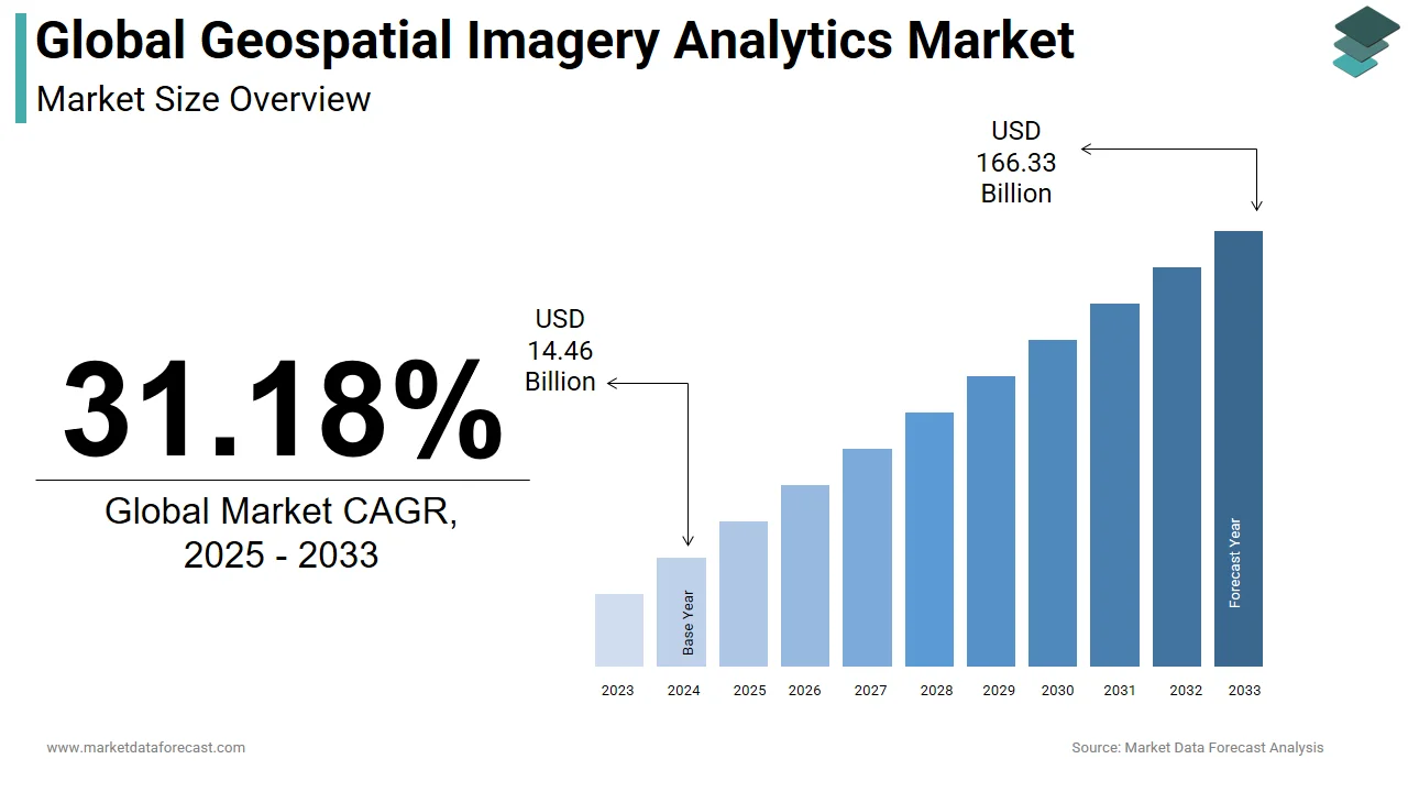
31.18%Global Geospatial Imagery Analytics Market Size
The global geospatial imagery analytics market was valued at USD 18.97 billion in 2025. This market is expected to grow at a CAGR of 31.18% from 2026 to 2034 and be worth USD 218.21 billion by 2034, up from USD 24.88 billion in 2026.
Geospatial imaging analytics can be identified as tools for assisting and analyzing geospatial data received from satellite imagery, Global Positioning Systems, or mapping sources to generate helpful information for making critical business choices. The geospatial imaging analytics system is a platform built on big data analytics, which also includes predictive analytics. It assists both public and corporate sectors in making important business decisions, as well as risk assessment and catastrophe management, urban development, and climatic conditions. In comparison to 3D and 2D analysis, geospatial imaging analysis provides more specific images.
eospatial analytics adds context to traditional data by combining timing and location, allowing for a fuller picture of events. Insights that would have been lost in a vast spreadsheet are exposed in visual originals and images that are easy to recognize. Large amounts of geographic and geometric data can be processed quickly by geospatial analytics companies. As a result, users can communicate with billions of mapped locations while viewing real-time geospatial representations. In large datasets, geospatial data analytics provides an eye to distinguish exemplars like distance, closeness, contiguity, and association.
MARKET TRENDS
For a brief period of time, the software and service industries are also estimated to slow down. However, in the latter half of the year, usage of collaborative applications, location-based applications, security solutions, big data, and AI is predicted to grow. Despite the pandemic's impact on the geospatial imaging analytics industry, businesses continued to use geospatial imagery analytics solutions and hardware for facility management, virus tracking, people tracking and direction, and intelligent quarantining. Governments and commercial enterprises across sectors are implementing geospatial imaging analytics solutions to keep citizens indoors and follow them, resulting in market growth throughout the forecast period.
MARKET DRIVERS
The global geospatial imagery analytics market is mostly driven by rising disposable incomes and advances in analytics technology.
Another critical element driving market expansion is the growing demand for geospatial imaging analytics for national security and safety. The need for geospatial data in the mining, manufacturing, engineering, and construction sectors is likely to enhance the expansion of the Geospatial Imagery Analytics Market worldwide. Moreover, technological advancements in this area have improved the popularity of geospatial technologies such as remote sensing (R.S.), a global positioning system (GPS), and geographical information systems (GIS), among others, resulting in market growth.
MARKET RESTRAINTS
Geographical variances in data gathering techniques, location privacy, intellectual property rights, data licensing, and geospatial data storage limit the use of geospatial imaging analytics systems. Such legal issues must be considered by geospatial technology suppliers to ensure significant public and private geospatial initiatives. Furthermore, the market's growth is likely to be hampered by tight government laws surrounding geospatial data and data integration with business solutions during the research period.
REPORT COVERAGE
| REPORT METRIC | DETAILS |
| Market Size Available | 2025 to 2034 |
| Base Year | 2025 |
| Forecast Period | 2026 to 2034 |
| CAGR | 31.18% |
| Segments Covered | By Technology, Imaging Type, Vertical, And Region |
|
Various Analyses Covered | Global, Regional & Country Level Analysis, Segment-Level Analysis, DROC, PESTLE Analysis, Porter’s Five Forces Analysis, Competitive Landscape, Analyst Overview on Investment Opportunities |
| Regions Covered | North America, Europe, APAC, Latin America, Middle East & Africa |
|
Market Leaders Profiled | Satellite Imaging Corporation, Fugro N.V., Environmental Systems Research Institute, Harris Corporation, Hexagon AB, KeyW Corporation, DigitalGlobe, UrtheCast Corporation, Trimble, and others. |
SEGMENTAL ANALYSIS
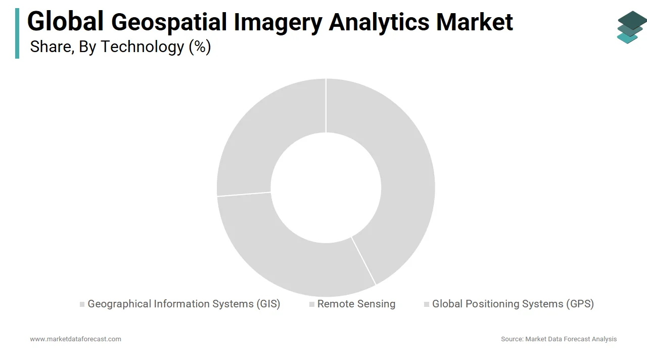
By Technology Insights
Due to the increased use of GIS in remote sensing, the GIS collection segment accounts for the most significant part of the geospatial imagery analytics market and is expected to grow at the fastest rate over the projected period. It can also be used to search for geographic patterns in data and depict them on a map to assess future risks and contingency plans.
By Imaging Type Insights
The majority of the geospatial imagery analytics market is dominated by image-based analytics. During the projected period, however, video-based analytics is expected to grow at the fastest rate. Businesses' rising deployment of drones and surveillance cameras to review and use video content to assist their everyday operations is one factor contributing to the segment's growth.
By Vertical Insights
For the forecast period, the agriculture segment is expected to have the most significant CAGR. The increasing deployment of drones and remote sensing platforms to improve farming operations by analyzing geospatial data is one aspect that can contribute to the segment's rise. This technology also assists the agriculture business in ensuring the safety of crops and the efficient use of natural resources.
REGIONAL ANALYSIS
Because of improvements in the use of the Internet of Things (IoT), Machine Learning (ML), big data, and Artificial Intelligence (AI) and its integration with geospatial technologies for better communication, North America is expected to hold the most significant market size over the projection period.
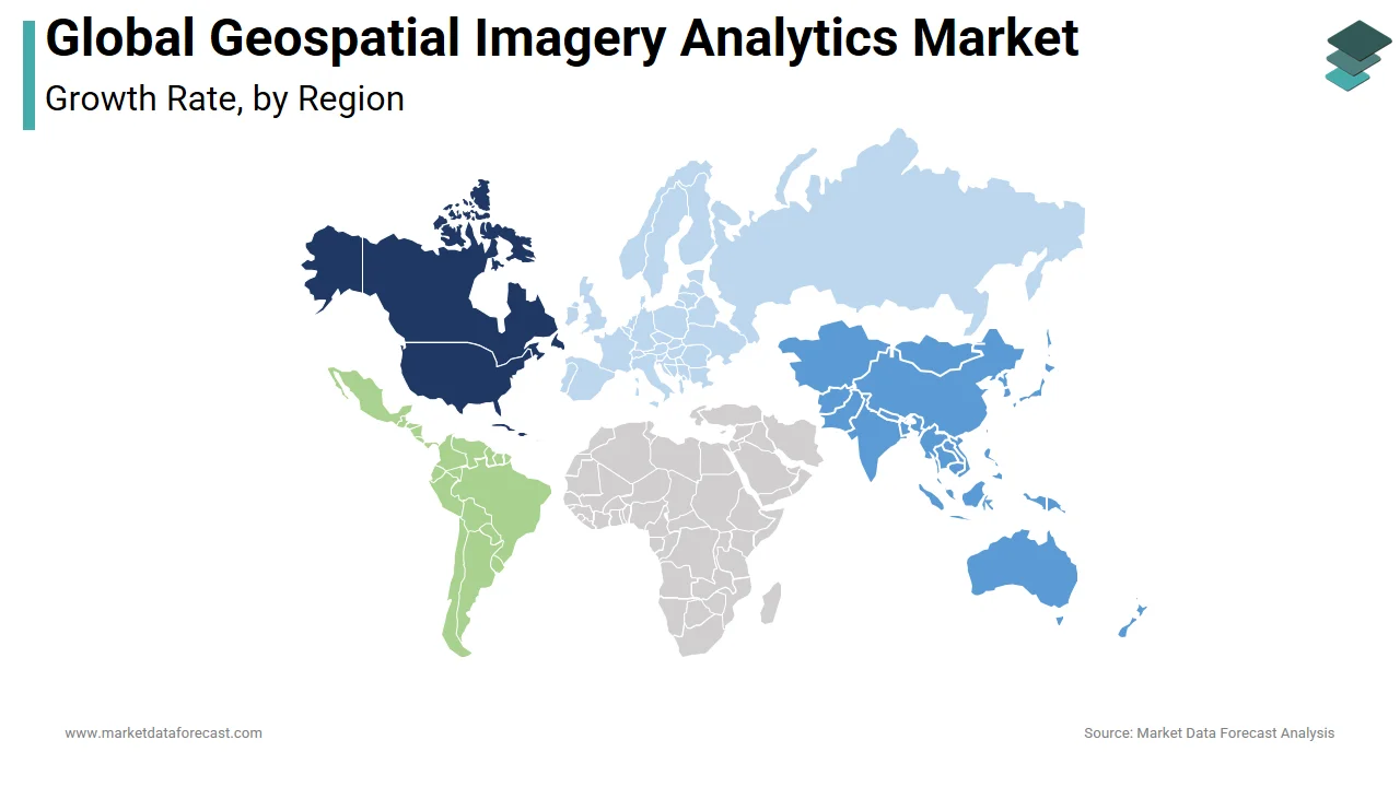
Due to the increase in the number of startups and government support in geospatial technology in this region, Asia-Pacific will have the most significant CAGR for this time.
During the forecast period, the European geospatial Imagery Analytics Market is expected to increase at a rate of 29.0% CAGR during the forecast period. The German market dominated the European geospatial Imagery Analytics Market by Country, and it is expected to continue the same trend through out the forecast period. The U.K. market is likely to develop at a CAGR of 27.9%. In addition, the France market is expected to grow at a rate of 29.9% during the next five years.
During the projected period, the geospatial analytics market in the Middle East and Africa is expected to increase at a CAGR of 16.84 percent. The geospatial analytics market in the Middle East and Africa is rapidly expanding. The market in the region is majorly fuelled by increasing infrastructure development and Saudi Arabia's central government initiatives. Saudi Arabia is likewise concentrating on the advancement and implementation of geospatial imaging.
KEY MARKET PLAYERS
Satellite Imaging Corporation, Fugro N.V., Environmental Systems Research Institute, Harris Corporation, Hexagon AB, KeyW Corporation, DigitalGlobe, UrtheCast Corporation, Trimble, and others.
MARKET SEGMENTATION
This research report on the global geospatial imagery analytics market has been segmented and sub-segmented based on the technology, imaging type, vertical, and region.
By Technology
-
Geographical Information Systems (GIS)
-
Remote Sensing
-
Global Positioning Systems (GPS)
By Imaging Type
-
Image
-
Video
By Vertical
-
Healthcare
-
Defense
-
Government
-
Security
-
Environment Monitoring
-
Engineering and Construction
-
Agriculture
-
Energy and Utilities
-
Others
By Region
-
North America
-
Europe
-
Asia Pacific
-
Latin America
-
Middle East & Africa
Frequently Asked Questions
What are the key applications of geospatial imagery analytics on a global scale?
Geospatial imagery analytics find applications across various sectors such as defense and intelligence, agriculture, urban planning, natural resource management, environmental monitoring, and disaster management.
What technological advancements are driving innovation in the global geospatial imagery analytics market?
Technological advancements such as artificial intelligence (AI), machine learning (ML), cloud computing, and unmanned aerial vehicles (UAVs) are driving innovation in the geospatial imagery analytics market. These technologies enable faster and more accurate analysis of geospatial data, leading to improved decision-making.
How are advancements in AI and machine learning impacting the global geospatial imagery analytics market?
Advancements in AI and machine learning are revolutionizing the geospatial imagery analytics market by enabling automated feature extraction, object recognition, change detection, and predictive analytics. These technologies enhance the efficiency and accuracy of geospatial data analysis, leading to better insights and decision-making.
How is the adoption of geospatial imagery analytics contributing to sustainable development goals (SDGs) globally?
The adoption of geospatial imagery analytics supports several sustainable development goals (SDGs) such as poverty alleviation, food security, sustainable cities and communities, climate action, and environmental conservation. By providing actionable insights derived from geospatial data, analytics solutions contribute to informed decision-making and sustainable development initiatives worldwide.
Related Reports
Access the study in MULTIPLE FORMATS
Purchase options starting from
$ 2500
Didn’t find what you’re looking for?
TALK TO OUR ANALYST TEAM
Need something within your budget?
NO WORRIES! WE GOT YOU COVERED!
Call us on: +1 888 702 9696 (U.S Toll Free)
Write to us: sales@marketdataforecast.com