Global Satellite Data Services Market Size, Share, Trends, & Growth Forecast Report by Vertical (Energy & Power, Defense & Security, Environmental, Agriculture, Maritime, Forestry, Insurance, Engineering and Infrastructure, Transportation and Logistics, etc.), Services (Data Analytics, Image Data), End-Users (Commercial, Government & Military), & Region - Industry Forecast From 2025 to 2033
Global Satellite Data Services Market Size
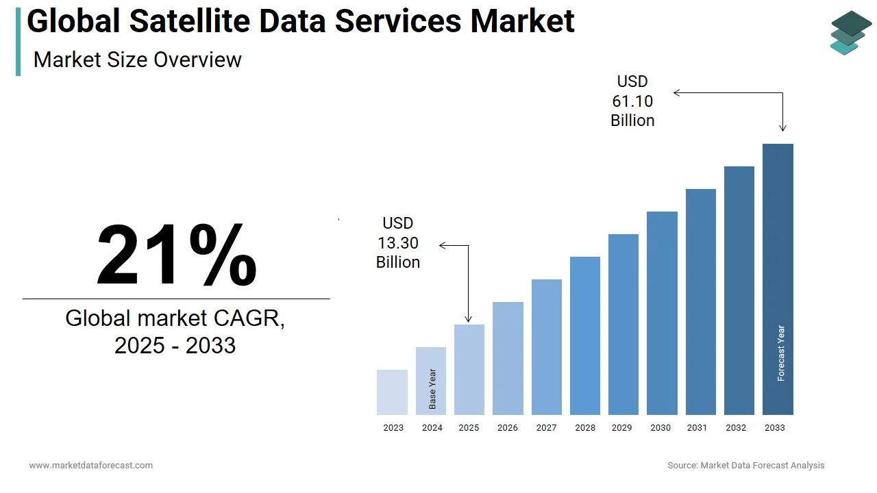
The global satellite data services market was worth USD 10.99 billion in 2024. The global market is predicted to reach USD 13.30 billion in 2025 and USD 61.10 billion by 2033, growing at a CAGR of 21.0% over the outlook period.
The satellite data is used to observe Earth, providing information on the chemical, physical, and biological characteristics of the Earth. Key advancements in geospatial imagery examination combined with the application of AI and big data, privatization of the space industry, and increasing demand for small earth observation satellites are driving the market. Satellite data services involve providing data about Earth, which is generated and gathered by man-made satellites revolving around the Earth’s orbit. Satellite data, which incorporates information about the chemical, physical, and biological characteristics of the Earth, is most commonly utilized in the observation of Earth. The worldwide satellite data services market is emerging and is projected to grow at a substantial rate during the forecast period. The market is fueled by substantial advancements in geospatial imagery analytics, including the introduction of AI (AI) and big data, privatization of the space industry, and increasing demand for small satellites for earth observation.
MARKET TRENDS
Increased adoption of AI and machine learning (ML) within the space sector has created numerous opportunities for service providers to supply AI and ML-integrated solutions. The AI-based platforms provide deep insights on complex factors like social, industrial, and economic processes. ML algorithms are increasingly wont to process daily satellite imagery to classify and detect objects, locate geographic and topographic features, and to watch minute changes over a span of your time. Defense contractors, like Lockheed Martin Corporation, has developed a satellite imagery recognition system, the Global Automated Target Recognition (GATR). This technique leverages open-source deep learning libraries to classify and identify big datasets during a faster and more efficient method.
Satellite data is widely utilized in the event of smart cities and connected vehicles. The urban planners are using these data to know settlement trends and ensure efficient infrastructure management. Increased usage of remote sensing technology for zoning and city infrastructure modeling, has helped in meeting the incrementing demands from city-based populations towards better management of sustainable urban development. Additionally, rising urban agglomeration and monitoring urbanization of adjoining areas to enable smart town planning and implementation is further augmenting satellite imagery adoption.
MARKET DRIVERS
Privatization of the space industry is one among the main factors boosting the expansion of the global satellite data services market. The target of privatizing the industry is to expand upon the use of the industry landscape by exploring opportunities where the private sector can provide enjoy satellite services. As an example, the newest commercial service agreements cost only about $50 million per spacecraft launch, while earlier this cost was about $4 billion per annum.
In addition, the increasing number of satellites within the space and up surging data generation through these satellites are further benefiting the expansion of the market. For instance, in the beginning of 2020, Space Exploration Technologies Corp. (SpaceX) became the primary company to work largest active satellite constellation across the planet, with 180 satellites orbiting the world. The company further aims to launch about 42,000 satellites over subsequent decade, which is around 21 times the amount of satellites operating within the space at the present. Such factors are propelling the expansion of the global satellite data services market.
REPORT COVERAGE
| REPORT METRIC | DETAILS |
| Market Size Available | 2024 to 2033 |
| Base Year | 2024 |
| Forecast Period | 2025 to 2033 |
| CAGR | 21% |
| Segments Covered | By Vertical, End Use, Service, and Region |
|
Various Analyses Covered | Global, Regional & Country Level Analysis, Segment-Level Analysis, DROC, PESTLE Analysis, Porter’s Five Forces Analysis, Competitive Landscape, Analyst Overview on Investment Opportunities |
| Regions Covered | North America, Europe, APAC, Latin America, Middle East & Africa |
|
Market Leaders Profiled | Airbus SE (Netherlands), Harris Geospatial Solutions, Inc (US), DigitalGlobe (US), Satellite Imaging Corporation (US), Planet Labs, Inc.(US), ICEYE (Finland) and Land Info Worldwide Mapping (US) and Others. |
REGIONAL ANALYSIS
North America dominated the marketplace for satellite data services by capturing over 33% revenue share in 2019. The formulation of the new National Space Strategy enables the govt to partner with companies within the commercial sector such they will establish a prominent defense system against threats from space-bound attacks. Additionally, U.S. distributes images captured by the Landsat satellite freely, thus promising productivity saving and economic benefits for users. Such initiatives have resulted within the emergence of several small satellite manufacturers that provide continuous feed about the earth’s surface.
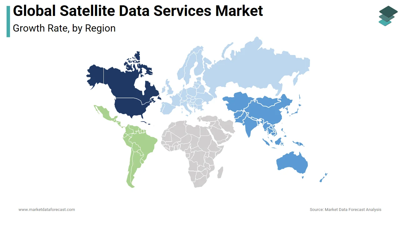
Europe captured significant market share in 2019 and is predicted to exhibit a gradual rate of growth over the forecast period. The European Union has collaborated with other international institutions to introduce several acts and initiatives like the Common Agriculture Policy (CAP), the UN Convention for Combating Desertification and Land Degradation, and the Soil Framework Directive. These institutions leverage data provided by the Copernicus Hyperspectral Imaging Mission for the Environment (CHIME) mission for purchasers. Moreover, economies including The Netherlands have devised their own imagery portal, the National Satellite Data Portal, managed by Netherlands Space Office (NSO) to strategically manage the demand and provide side of its satellite-based imagery.
KEY MARKET PLAYERS
The major players within the global satellite data services market are Airbus SE (Netherlands), Harris Geospatial Solutions, Inc (US), DigitalGlobe (US), Satellite Imaging Corporation (US), Planet Labs, Inc.(US), ICEYE (Finland) and Land Info Worldwide Mapping (US), among others. These players have adopted various growth strategies like contracts, acquisitions, expansions, new product launches, and partnerships & agreements to expand their presence within the satellite data services further.
RECENT MARKET HAPPENINGS
- In Mar 2020, Planet Labs contracted partnership agreement with Seisan which is a custom software solution and systems integration company.
- In Feb 2020, L3Harris signed an agreement with The Air Force Life Cycle Management Center. The agreement aims to develop a software platform that might make it easier for analysts to use AI (AI) to spot objects in large data sets.
- In Jan 2020, L3Harris extended its deal with exactEarth Ltd., a leading company offering Satellite-AIS data services. The agreement is likely to deliver a reduced and streamlined cost structure for L3Harris' data services.
MARKET SEGMENTATION
This research report on the global satellite data services market has been segmented and sub-segmented based on the vertical, end-use, service, and region.
By Vertical
- Energy & Power
- Engineering & Infrastructure
- Defense & Security
- Environmental
- Agriculture
- Maritime
- Forestry
- Transportation & Logistics
- Insurance
By End-Use
- Commercial
- Government & Military
By Service
- Data Analytics
- Image Data
By Region
- North America
- Europe
- Asia-Pacific
- Latin America
- The Middle East and Africa
Frequently Asked Questions
What are the key drivers of growth in the Satellite Data Services Market?
The key drivers include the increasing demand for high-resolution satellite imagery, advancements in satellite technology, rising need for real-time data in various sectors, and growing applications in environmental monitoring and disaster management.
What are the main applications of satellite data services?
Major applications include weather forecasting, environmental monitoring, agricultural management, disaster response, urban planning, defense and security, maritime monitoring, and telecommunications.
What technological advancements are impacting the Satellite Data Services Market?
Significant advancements include improvements in satellite imagery resolution, enhanced data processing capabilities, development of small and nanosatellites, increased use of artificial intelligence and machine learning for data analysis, and advancements in remote sensing technologies.
What challenges does the Satellite Data Services Market face?
Challenges include high costs of satellite launch and maintenance, data privacy and security concerns, regulatory and licensing issues, and the need for significant technological infrastructure for data processing and analysis.
Related Reports
Access the study in MULTIPLE FORMATS
Purchase options starting from
$ 2500
Didn’t find what you’re looking for?
TALK TO OUR ANALYST TEAM
Need something within your budget?
NO WORRIES! WE GOT YOU COVERED!
Call us on: +1 888 702 9696 (U.S Toll Free)
Write to us: sales@marketdataforecast.com