- Product Description Description
- Table of Contents TOC
- List of Table & Figure LOT
- Get Free Sample PDF Sample PDF
Market Size, 2025
$1.68 BnMarket Estimate, 2026
$2 BnMarket Forecast, 2034
$8.24 BnCAGR, 2026–2034
19.33%Asia Pacific 3D Mapping and Modeling Market Size
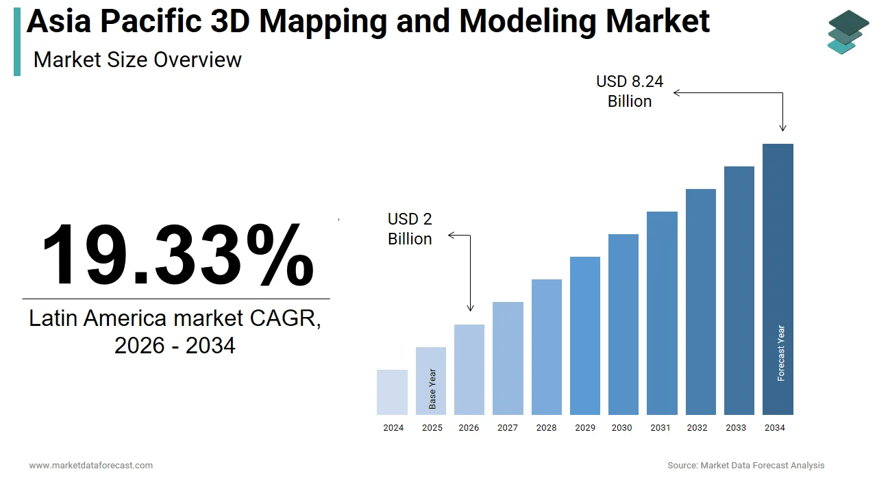
The Asia Pacific 3D mapping and modeling market was valued at USD 1.68 billion in 2025, is estimated to reach USD 2 billion in 2026, and is projected to reach USD 8.24 billion by 2034, growing at a CAGR of 19.33% from 2026 to 2034.
The 3D mapping and modeling is the digital representation of physical environments using technologies such as LiDAR, photogrammetry, terrestrial laser scanning, and drone-based imaging systems. These models serve as foundational tools in urban planning, infrastructure development, disaster resilience, and smart city deployment, enabling stakeholders to visualize, simulate, and analyze complex geospatial data with millimeter-level precision. Additionally, Australia’s National Spatial Strategy reported that federal and state agencies collectively generated more than 4.2 petabytes of geospatial data through aerial LiDAR surveys in 2022, supporting flood modeling and bushfire risk assessment.
MARKET DRIVERS
Accelerated Smart City Development and Urban Digital Twin Deployment
The rapid rollout of smart city initiatives with the adoption of 3D mapping and modeling technologies is driving the growth of the Asia Pacific 3D mapping and modeling market. As of 2023, there were 127 active smart city projects in the region, according to the United Nations Economic and Social Commission for Asia and the Pacific, with Singapore, Seoul, and Sydney leading in integrated urban digital twin implementation. Singapore’s Virtual Singapore initiative, a fully interactive 3D model of the city-state, is used for solar radiation analysis, emergency response planning, and traffic flow optimization, integrating real-time data from over 100,000 IoT sensors. Similarly, Seoul’s Digital Twin Seoul project, launched in 2022, covers 70% of the metropolitan area and supports urban planning decisions through simulation of population movement and infrastructure stress. In Australia, the New South Wales government completed a 3D city model of Sydney in 2023, covering 3,000 square kilometers with 10-centimeter resolution, enabling precise flood modeling and utility network management. The Indian Ministry of Housing and Urban Affairs reported that 100 Smart Cities Mission projects have incorporated 3D GIS platforms for infrastructure tracking, with over 80% utilizing drone-based photogrammetry for cadastral updates. As per the World Bank, urban populations in the Asia Pacific are expected to grow by 320 million by 2030, intensifying pressure on city planners to adopt advanced spatial tools.
Expansion of High-Precision Infrastructure and BIM Mandates in Construction
The construction sector is a technological shift driven by the mandatory adoption of Building Information Modeling (BIM) and the need for high-accuracy surveying in large-scale infrastructure projects, which is escalating the growth of the Asia Pacific 3D mapping and modeling market. Governments in Japan, South Korea, and Singapore have enforced BIM compliance for all public infrastructure developments, requiring 3D digital models to be submitted at every project phase. In This policy has spurred demand for terrestrial laser scanning and drone-based 3D mapping to generate as-built models with sub-centimeter accuracy. South Korea’s Korea Infrastructure Safety Corporation reported that BIM-integrated projects experienced a 26% reduction in rework and a 19% decrease in construction delays.
MARKET RESTRAINTS
Fragmented Regulatory Frameworks and Lack of Standardized Data Protocols
The absence of harmonized regulatory standards and interoperable data formats across jurisdictions is hindering the growth of the Asia Pacific 3D mapping and modeling market. As per the Asia-Pacific Economic Cooperation (APEC) Digital Economy Report 2023, only 39% of member economies have adopted common data exchange protocols for spatial information, leading to siloed datasets and duplication of survey efforts. The United Nations Global Geospatial Information Management initiative found that over 55% of municipal authorities in Southeast Asia use incompatible GIS platforms, hindering regional disaster response coordination. Additionally, legal uncertainties around data ownership and privacy for drone-captured imagery have slowed deployment. Japan’s Ministry of Internal Affairs reported that 42% of drone surveying applications were delayed in 2023 due to unclear airspace regulations and consent requirements. In Vietnam, the absence of a national LiDAR policy has resulted in inconsistent data resolution across provinces, undermining model reliability.
High Costs and Limited Access to Advanced Surveying Equipment
The deployment of high-resolution 3D mapping systems is often restricted by the prohibitive cost of advanced equipment and the scarcity of skilled operators, particularly in developing economies across South and Southeast Asia. According to the Asian Development Bank, only 12% of land surveying companies in Cambodia, Laos, and Myanmar possess LiDAR-capable drones, relying instead on outdated topographic methods. The shortage of trained professionals further exacerbates the issue. UNESCO’s 2023 Technical Skills Assessment revealed a deficit of 86,000 geospatial technicians across the region, with Indonesia alone facing a shortfall of 18,000 qualified personnel. Additionally, maintenance and calibration of precision sensors require specialized facilities, which are concentrated in urban centers, leaving rural and remote areas underserved. According to the Pacific Community’s Geospatial Outlook 2023, only 30% of Pacific Island nations have conducted comprehensive 3D coastal mapping due to logistical and financial barriers. This technological disparity limits the scalability of 3D modeling applications in areas such as floodplain management, infrastructure planning, and climate adaptation, particularly in regions most vulnerable to environmental risks.
MARKET OPPORTUNITIES
Integration with Artificial Intelligence and Automated Feature Extraction
The integration of 3D mapping with artificial intelligence (AI) and machine learning to enhance data processing speed, accuracy, and analytical depth across the Asia Pacific is creating new opportunities for the growth of the Asia Pacific 3D mapping and modeling market. Traditional 3D modeling workflows require extensive manual interpretation to identify structures, roads, and vegetation from point cloud data, a process that can take weeks. However, AI-powered algorithms can now automatically classify and extract features with over 90% accuracy, drastically reducing post-processing time. In 2023, the Australian Centre for Field Robotics developed an AI model capable of identifying building footprints and roof types from drone LiDAR data in under two hours, a task that previously required 40 hours of manual labor. As per the OECD Digital Government Index, AI integration in geospatial workflows has improved decision-making efficiency by 34% in public sector projects across the region. Furthermore, companies like SenseTime and NEC are developing edge-AI solutions that enable on-device processing of 3D data by reducing reliance on cloud infrastructure.
Application in Climate Resilience and Natural Disaster Risk Modeling
The increasing frequency and intensity of climate-related disasters are escalating the growth of the Asia Pacific 3D mapping and modeling market. The region accounts for over 70% of global disaster-related fatalities, according to the United Nations Office for Disaster Risk Reduction, with cyclones, floods, and landslides affecting millions annually. High-resolution 3D terrain models are now essential for simulating flood inundation, landslide susceptibility, and storm surge impacts with unprecedented accuracy. In 2023, the Philippines’ Department of Science and Technology deployed a nationwide 3D flood modeling system using LiDAR data from 38 river basins, enabling barangay-level evacuation planning. Similarly, Indonesia’s National Agency for Disaster Countermeasure (BNPB) integrated 3D city models of Jakarta and Bandung into its Early Warning System, improving flood prediction lead time by 48 hours. Australia’s Bureau of Meteorology used 3D elevation models to simulate bushfire spread under varying wind conditions by enhancing emergency response coordination during the 2023 fire season.
MARKET CHALLENGES
Data Security and Sovereignty Concerns in Cross-Border Geospatial Collaboration
The increasing reliance on cloud-based 3D modeling platforms and international data sharing is also inhibiting the growth of the Asia Pacific 3D mapping and modeling market. Sensitive topographic, infrastructure, and defense-related spatial data are often collected by foreign-owned drone operators or processed through overseas servers, triggering national security alerts. Similarly, China’s Cybersecurity Administration enforced strict data localization rules, which require all geospatial information collected within its borders to be stored and processed domestically. As per the Asia-Pacific Risk Centre, 62% of governments in the region have tightened regulations on foreign access to geospatial datasets since 2021.
Rapid Urbanization Outpacing Data Collection and Model Updating Cycles
The pace of urban transformation, with the ability of 3D mapping systems to capture and update digital models in real time, is also expected to impede the growth of the Asia Pacific 3D mapping and modeling market. Megacities such as Dhaka, Ho Chi Minh City, and Hyderabad are expanding at rates exceeding 4% annually, with informal settlements and ad-hoc construction altering landscapes faster than survey cycles can capture. According to the United Nations Human Settlements Programme, the region adds over 40 million new urban residents each year, necessitating continuous spatial monitoring. However, most municipal 3D city models are updated only once every 18 to 36 months, rendering them ineffective for real-time planning. In Jakarta, where land subsidence reaches 25 centimeters per year in some areas, outdated elevation models compromise flood forecasting accuracy. The Asian Development Bank reported that 58% of urban infrastructure projects in secondary cities rely on geospatial data older than three years. Additionally, drone-based surveys face logistical barriers in dense urban canyons, while satellite revisits may occur only weekly or monthly.
REPORT COVERAGE
| REPORT METRIC | DETAILS |
| Market Size Available | 2025 to 2034 |
| Base Year | 2025 |
| Forecast Period | 2026 to 2034 |
| Segments Covered | By Offering, Technology, Vertical, and Country. |
| Various Analyses Covered | Global, Regional, and Country-Level Analysis, Segment-Level Analysis, Drivers, Restraints, Opportunities, Challenges; PESTLE Analysis; Porter’s Five Forces Analysis, Competitive Landscape, Analyst Overview of Investment Opportunities |
| Countries Covered | India, China, Japan, South Korea, Australia, New Zealand, Thailand, Malaysia, Vietnam, Philippines, Indonesia, Singapore, Rest of APAC |
| Market Leaders Profiled | Google, Autodesk, Trimble, Bentley Systems, Dassault Systèmes, Adobe, Hexagon, Esri, Golden Software, Maxon, Topcon, CyberCity 3D, Pix4D, Apple, Onionlab, Mapbox, Saab AB, Airbus, Intermap Technologies, The Foundry Visionmongers, PTC, MathWorks, Ansys, Blender Foundation, SideFX, Civil Maps, Hivemapper, lvl5, Shapr3D, Innersight, Astrivis Technologies, Pointivo, Dynamic Map Platform, Archilogic, MOD Tech Labs, and Others. |
SEGMENT ANALYSIS
By Offering Insights
The services segment dominated the Asia Pacific 3D mapping and modeling market by capturing 58.3% of share in 2024, with the inherently project-based nature of 3D spatial deployment, where end-users require specialized expertise in data acquisition, processing, integration, and interpretation functions that transcend off-the-shelf software capabilities. Large-scale infrastructure developments acrossthe Asia Pacific necessitate end-to-end 3D mapping services due to the complexity of terrain, regulatory requirements, and integration with Building Information Modeling (BIM) systems. As per the Ministry of Road Transport and Highways, more than 92% of highway projects initiated in 2023 involved third-party geospatial service providers for corridor mapping using mobile LiDAR systems. These efforts demand not only data capture but also advanced processing to generate classified point clouds, digital elevation models, and 3D cityscapes.
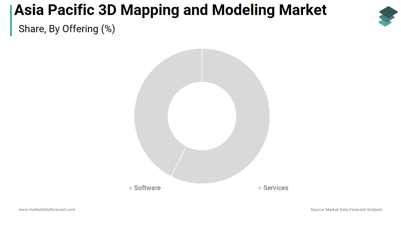
The software segment is growing lucratively with an expected CAGR of 14.6% from 2026 to 2034, with the rising adoption of cloud-based 3D modeling platforms, AI-integrated processing tools, and enterprise-grade software for real-time visualization and simulation. The proliferation of cloud-native 3D modeling software equipped with artificial intelligence is transforming how spatial data is processed and utilized acrossthe Asia Pacific. Traditional desktop-based software required high-end workstations and manual processing, but modern platforms like Bentley’s ContextCapture SaaS and Autodesk ReCap Pro now enable automated point cloud generation, feature extraction, and mesh creation via cloud computing. Singapore’s Virtual Singapore initiative relies on a centralized cloud software backbone to integrate real-time sensor data with 3D city models for urban analytics. The Korea Institute of Science and Technology noted that AI-powered software reduced manual classification effort in LiDAR data by 85% across 12 metropolitan mapping projects in 2023.
By Technology Insights
The LiDAR segment accounted in holding 52.3% of the Asia Pacific 3D mapping and modelling market share in 2024. LiDAR’s ability to deliver sub-decimeter accuracy and penetrate dense vegetation has made it indispensable for large-scale land surveys in geographically complex regions across the Asia Pacific. The Indonesian Ministry of Environment and Forestry conducted a nationwide LiDAR campaign in 2023, mapping 120,000 square kilometers of rainforest to assess carbon stocks and illegal logging, achieving vertical accuracy of 15 centimeters.
The SLAM technology segment is projected to grow at a CAGR of 17.3% from 2023 to 2030, according to the Institute of Electrical and Electronics Engineers (IEEE). This rapid expansion is fueled by its application in dynamic, GPS-denied environments such as indoor spaces, underground tunnels, and dense urban canyons, where traditional LiDAR and photogrammetry fail. SLAM-powered mobile mapping systems are increasingly used to map subterranean and enclosed environments where GPS signals are unavailable, including subway tunnels, utility corridors, and industrial plants. In 2023, the Delhi Metro Rail Corporation deployed SLAM-equipped backpack scanners to generate 3D models of 120 kilometers of underground stations and tunnels, achieving centimeter-level accuracy without disrupting operations.
By Vertical Insights
The Architecture, Engineering & Construction (AEC) sector was the largest and held 46.3% of the Asia Pacific 3D mapping and modeling market share in 2024. Governments across the Asia Pacific are enforcing Building Information Modeling (BIM) mandates for public construction projects, necessitating the integration of 3D mapping data into digital workflows. These projects use drone-based photogrammetry and terrestrial LiDAR to generate as-built models for clash detection and progress tracking. Singapore’s Building and Construction Authority mandates Level 3 BIM for all government buildings, requiring real-time 3D model updates. According to the Indian Ministry of Housing and Urban Affairs, 82% of Smart Cities Mission projects now use 3D GIS platforms for infrastructure monitoring.
The Media & Entertainment vertical segment is lucratively growing with an expected CAGR of 15.8% from 2026 to 2034. In South Korea, CJ ENM launched a virtual production hub in 2023, using LiDAR-scanned sets to create dynamic digital backdrops for K-dramas, reducing location shooting costs by 40%. Museums, theme parks, and cultural institutions are leveraging 3D mapping to create immersive digital experiences is driving demand for high-fidelity modeling. In Japan, the Kyoto National Museum launched a virtual tour using 3D-scanned artifacts, increasing online engagement by 210% in 2023. The UNESCO Asia-Pacific Cultural Heritage Report confirmed that 38% of major museums in the region now offer VR walkthroughs based on 3D models. In China, Tencent partnered with Dunhuang Academy to create a metaverse experience of the Mogao Grottoes, attracting over 5 million users.
COUNTRY LEVEL ANALYSIS
China 3D Mapping and Modeling Market Insights
China was the top performer in the Asia Pacific 3D mapping and modeling market by accounting for 36.3% of the share in 2024 with its state-driven digital infrastructure agenda, which prioritizes geospatial intelligence for urban governance, disaster resilience, and military-civil integration. The Ministry of Natural Resources launched the “Digital China” initiative, aiming to complete nationwide 3D city modeling by 2025, with over 300 cities already generating digital twins. In 2023, Beijing deployed a real-time 3D traffic monitoring system using LiDAR and AI, reducing congestion by 24%. According to the National Remote Sensing Center, China operates the largest fleet of survey drones in the region, conducting over 1.2 million flight hours annually. Additionally, BIM mandates for all government construction projects have spurred demand for 3D modeling services.
India 3D Mapping and Modeling Market Insights
India was positioned second by holding the Asia Pacific 3D mapping and modeling market with 18.2% of share in 2024 with the large-scale infrastructure programs and urban digitization efforts under the Smart Cities Mission and Digital India. The Survey of India is executing the largest LiDAR mapping program in South Asia, which is covering 2.5 million square kilometers to support flood modeling and land titling. The Ministry of Housing and Urban Affairs reported that 92 of the 100 smart cities now use 3D GIS platforms for asset management. Additionally, private firms like Genesys International and Geoweb360 are expanding drone-based services for telecom tower and solar farm planning.
Japan 3D Mapping and Modeling Market Insights
Japan's 3D mapping and modeling market is substantially to grow with the highest CAGR during the forecast period, with its integration of high-precision spatial data into national resilience and urban planning frameworks. The Digital Twin City Program, launched in 2022, includes 40 municipalities using real-time 3D models for earthquake simulation and evacuation planning. The Ministry of Land, Infrastructure, Transport and Tourism mandates BIM for all major infrastructure projects, which is driving the adoption of terrestrial laser scanning and drone surveys. In 2023, the Tokyo Metropolitan Government completed a 3D model of 80% of the city with 5-centimeter resolution by supporting seismic retrofitting assessments. According to the Japan Society of Photogrammetry and Remote Sensing, over 70% of public works projects now require as-built 3D documentation.
South Korea 3D Mapping and Modeling Market Insights
South Korea 3D mapping and modeling market is contributing 11% of regional demand in 2023, according to the Korea Institute of Geoscience and Mineral Resources. The Digital Twin Seoul project is covering 70% of the capital, integrating real-time data from 500,000 IoT sensors into a 3D urban model for traffic, energy, and emergency management. In 2023, the Korea Land and Housing Corporation used 3D modeling to plan the new administrative city of Sejong, which is optimizing land use and utility networks.
Australia 3D Mapping and Modeling Market Insights
Australia 3D mapping and modeling market growth is driven by its advanced regulatory frameworks, scientific research, and application in environmental management. The National LiDAR Policy ensures standardized, high-resolution terrain data for all federal projects, with over 4.2 petabytes of geospatial data collected in 2022. The Bureau of Meteorology uses 3D elevation models for bushfire and flood forecasting, improving prediction accuracy by 38%. In mining, Rio Tinto and BHP deploy drone-based 3D mapping for pit optimization and safety monitoring. The Commonwealth Scientific and Industrial Research Organisation developed AI tools for automated feature extraction from aerial surveys.
COMPETITION OVERVIEW
Competition in the Asia Pacific 3D mapping and modeling market is characterized by a dynamic interplay between global technology leaders and emerging regional innovators, with differentiation increasingly defined by integration, intelligence, and localization. Established firms such as Trimble, Bentley, and Topcon maintain dominance through advanced hardware-software ecosystems and deep government partnerships, particularly in Japan, Australia, and South Korea. However, local players and startups are gaining traction by offering cost-effective, context-specific solutions for urban planning, disaster response, and land management in developing markets. The rise of AI-driven data processing and cloud-based modeling platforms is lowering entry barriers, enabling smaller firms to compete on analytics rather than scale. Differentiation now hinges on speed of data delivery, interoperability with national digital frameworks, and compliance with data sovereignty regulations. Companies are also competing on sustainability, with geospatial tools being deployed for climate adaptation and green infrastructure. Strategic alliances, technology localization, and after-sales support networks in fragmented markets like Indonesia and the Philippines.
KEY MARKET PLAYERS
Some of the noteworthy companies in the Asia Pacific 3D mapping and modeling market profiled in this report are
- Autodesk
- Trimble
- Bentley Systems
- Dassault Systèmes
- Adobe
- Hexagon
- Esri
- Golden Software
- Maxon
- Topcon
- CyberCity 3D
- Pix4D
- Apple
- Onionlab
- Mapbox
- Saab AB
- Airbus
- Intermap Technologies
- The Foundry Visionmongers
- PTC
- MathWorks
- Ansys
- Blender Foundation
- SideFX
- Civil Maps
- Hivemapper
- lvl5
- Shapr3D
- Innersight
- Astrivis Technologies
- Pointivo
- Dynamic Map Platform
- Archilogic
- MOD Tech Labs
TOP LEADING PLAYERS IN THE MARKET
- Trimble has established a dominant presence in the Asia Pacific 3D mapping and modeling market through its integrated hardware-software solutions tailored for construction, geospatial, and infrastructure applications. The company’s advanced total stations, LiDAR scanners, and drone-based imaging systems are widely deployed across large-scale urban development and transportation projects in India, Japan, and Australia. In 2023, Trimble launched its MX9 Mobile Mapping System in Singapore, enabling high-speed corridor mapping for smart highway projects across Southeast Asia. The company also strengthened its regional footprint by partnering with Japan’s Obayashi Corporation to integrate Trimble’s 3D modeling software into BIM workflows for high-rise construction. Additionally, Trimble expanded its training centers in Bangalore and Sydney to upskill local engineers in digital twin development and reality capture.
- Bentley Systems plays a pivotal role in shaping the digital infrastructure landscape across Asia Pacific through its comprehensive 3D modeling and digital twin platforms. The company’s OpenCities, ContextCapture, and iTwin technologies are extensively used in urban planning, transportation, and utility management projects in South Korea, Australia, and India. In 2023, Bentley collaborated with the New South Wales Government to develop a statewide digital twin for Sydney, integrating 3D mapping data from aerial surveys and IoT sensors to optimize infrastructure planning. The company also launched its iTwin Experience platform in Japan, supporting real-time simulation of urban energy consumption and flood resilience. Through partnerships with agencies like Singapore’s Land Authority and India’s National Highways Authority, Bentley has embedded its software into national digital engineering frameworks.
- Topcon Positioning Systems is expanding its influence in the Asia Pacific 3D mapping and modeling market by delivering high-precision surveying and imaging solutions for construction, agriculture, and disaster management. Headquartered in Japan, the company leverages regional proximity to drive innovation in mobile LiDAR, drone-based photogrammetry, and robotic total stations. In 2023, Topcon introduced its IP-S4 mobile mapping system in Thailand, designed for rapid road and rail corridor surveys in tropical conditions. The company also supplied 3D scanning equipment to Indonesia’s Nusantara Capital City Authority for topographic modeling of the new capital. Topcon’s collaboration with Japan’s Disaster Prevention Research Institute enabled real-time landslide monitoring using automated 3D deformation analysis.
TOP STRATEGIES USED BY KEY MARKET PARTICIPANTS
Key players in the Asia Pacific 3D mapping and modeling market are deploying multifaceted strategies to strengthen their regional influence. Product innovation remains central, with companies advancing AI-powered data processing, cloud-native platforms, and compact, high-resolution sensors for diverse environments. Strategic partnerships with government agencies, engineering firms, and academic institutions are being leveraged to align technology with national digital infrastructure programs. Capacity-building initiatives, including training centers and certification programs, are expanding to address the regional shortage of skilled professionals. Market expansion is being pursued through localized service hubs in emerging economies such as Vietnam and Indonesia, ensuring faster deployment and technical support. Technology integration is the integration of 3D modeling with BIM, IoT, and digital twins, is enhancing solution depth and customer retention. Additionally, companies are investing in sustainable applications, supporting climate resilience and urban decarbonization projects to align with public sector priorities. These strategies collectively enable firms to transition from equipment vendors to comprehensive spatial intelligence providers.
RECENT MARKET DEVELOPMENTS
- In January 2023, Trimble launched its MX9 Mobile Mapping System in Singapore, enabling high-speed, high-resolution corridor surveys for smart highway and rail projects across Southeast Asia, significantly enhancing data capture efficiency for infrastructure monitoring and urban planning.
- In May 2023, Bentley Systems partnered with the New South Wales Government to develop a statewide digital twin of Sydney using its iTwin platform, integrating 3D mapping data with real-time IoT feeds to support infrastructure resilience and urban development decision-making.
- In August 2023, Topcon Positioning Systems introduced its IP-S4 mobile mapping solution in Thailand, designed for rapid deployment in tropical environments, which supports road network digitization and floodplain modeling for regional transportation and disaster management agencies.
- In November 2023, Trimble expanded its engineering and training center in Bangalore, India, to upskill over 1,500 surveying professionals annually in 3D reality capture and BIM integration by strengthening its technical support network for public infrastructure projects.
- In February 2024, Bentley Systems launched iTwin Experience in Japan, a cloud-based digital twin platform enabling real-time simulation of urban energy use and flood impacts that supports municipal governments in meeting carbon neutrality and disaster resilience goals.
MARKET SEGMENTATION
This Asia Pacific 3D mapping and modeling market research report is segmented and sub-segmented into the following categories.
By Offering
- Software
- 3D Mapping Software
- 3D Projection Mapping
- GIS Mapping
- Drone Mapping
- Satellite and Aerial Imaging
- Other 3D Mapping Software
- 3D Modeling Software
- Solid Modeling
- Wireframe Modeling
- Surface Modeling
- Other 3D Modeling Software
- 3D Mapping Software
- Services
- Professional Services
- Training & Consulting
- System Integration & Implementation
- Support & Maintenance
- Managed Services
- Professional Services
By Technology
- LiDAR
- Photogrammetry
- Structured Light Scanning
- SLAM
- Other Technologies
By Deployment Mode
- Cloud
- On-premises
By Vertical
- Architecture, Engineering & Construction (AEC)
- Manufacturing
- Automotive & Transportation
- Healthcare & Life Sciences
- Media & Entertainment
- Government & Defense
- Education
- Agriculture
- Energy & Utilities
- Other Verticals
By Country
- India
- China
- Japan
- South Korea
- Rest Of APAC